FutureWater conducted a very interesting and innovative pilot project for TerraFirma (Mozambique) on using flying sensor imagery for cadastre mapping.
Flying sensor imagery was obtained through various flights in Quelimane, Mozambique for an area with small-scale agriculture. Field boundaries were determined with the flying sensor imagery using various classification and segmentation algorithms, namely R packages (kmeans, canny edges, superpixels, contours), QGIS GRASS segmentation package, and ilastik software.
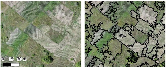
Results from the different algorithms and conclusions on recommended methods are published in this technical FutureWater report with some of the better results found for the QGIS GRASS segmentation package (see image below). Comparisons are also made between flying sensor imagery and high resolution satellite imagery, namely Google Earth, Digital Globe, and Planet data.