The latest Catch and Culture newsletter (pages 38-41), published by the Mekong River Commission Secretariat, features the pilot results of a new methodology for mapping of salinity concentrations (SIM) in the Mekong Delta. The method relies solely on satellite imagery and was developed and applied by FutureWater to support the 2023 MRC State of the Basin Report (SoBR).
Results show that the average area affected by salinity levels of over 4 g/L displayed a clear increasing trend over the last 30 years. In the 2011 – 2022 dry seasons, such severely elevated levels occurred on average for an area of 4,663 km2 (close to 10% of the transboundary Mekong Delta), a figure three times higher than in 1991 – 2000 (1,506 km2). Salinity concentrations of this magnitude are known to negatively impact on agricultural production, human health, and biodiversity. Elevated salinity levels particularly occur along the coastline of the Lower Delta, on the Ca Mau Peninsula, and in the coastal zone of Kien Giang Province.
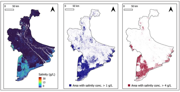
There is an encouraging agreement between this new methodology and station measurements, which are only available for a limited number of sites in the Mekong Delta. Future applications of the SIM are expected to benefit from incorporating data from new satellite-based sensors and enhanced calibration and validation based on additional field measurements. More information about the project can be found here.