La mayoría de las investigaciones recientes se han centrado en la identificación de episodios históricos basados en paleoregistros y la comprensión de sus causas climáticas, o en el estudio de megasequías “modernas” y sus impactos, generalmente en cuencas bajas y llanuras. Sin embargo, las cuencas de montaña han sido poco estudiadas y poco se sabe sobre el impacto de las megasequías en el estado y dinámica de la criosfera o torres de agua de montaña. Las cuencas vertientes dependientes de sistemas de alta montaña disponen de una capacidad para amortiguar la falta de precipitaciones y exceso de evapotranspiración que depende de las reservas de agua proporcionadas por la criosfera (nieve, glaciares y permafrost). Se presume, que la capacidad de amortiguación es limitada hasta alcanzar un punto de inflexión donde los impactos de la falta de agua y temperaturas extremas pueden verse amplificados y poner en peligro el funcionamiento del ecosistema hídrico.

MegaWat tiene un doble objetivo: 1) abordar las lagunas de conocimiento entorno a las causas hidroclimáticas de las sequías extremas y su impacto en el balance del agua de las torres de agua de montaña de Europa, haciendo especial énfasis en la concurrencia de eventos compuestos y los efectos en cascada y multiescala, y 2) desarrollar y proponer nuevas estrategias de adaptación para hacer frente a la duración, extensión e intensidad de futuras megasequías y sus impactos ambientales y socioeconómicos.

Para su implementación, MegaWat se centra en los sistemas de alta montaña de Europa y sus cuencas vertientes. MegaWat ambiciona el desarrollo de tres productos:

  • Producto 1. Marco metodológico para la identificación y caracterización de megasequías históricas durante el periodo instrumental, y la evaluación del papel que juega la criosfera en la amortiguación de los impactos del cambio climático y el desarrollo territorial en las cuencas vertientes. El producto 1 descansa en la combinación de herramientas de regionalización climática, modelización del balance de energía en superficie, simulación hidrológica, y códigos de evaluación y asignación optimización de recursos hídricos.
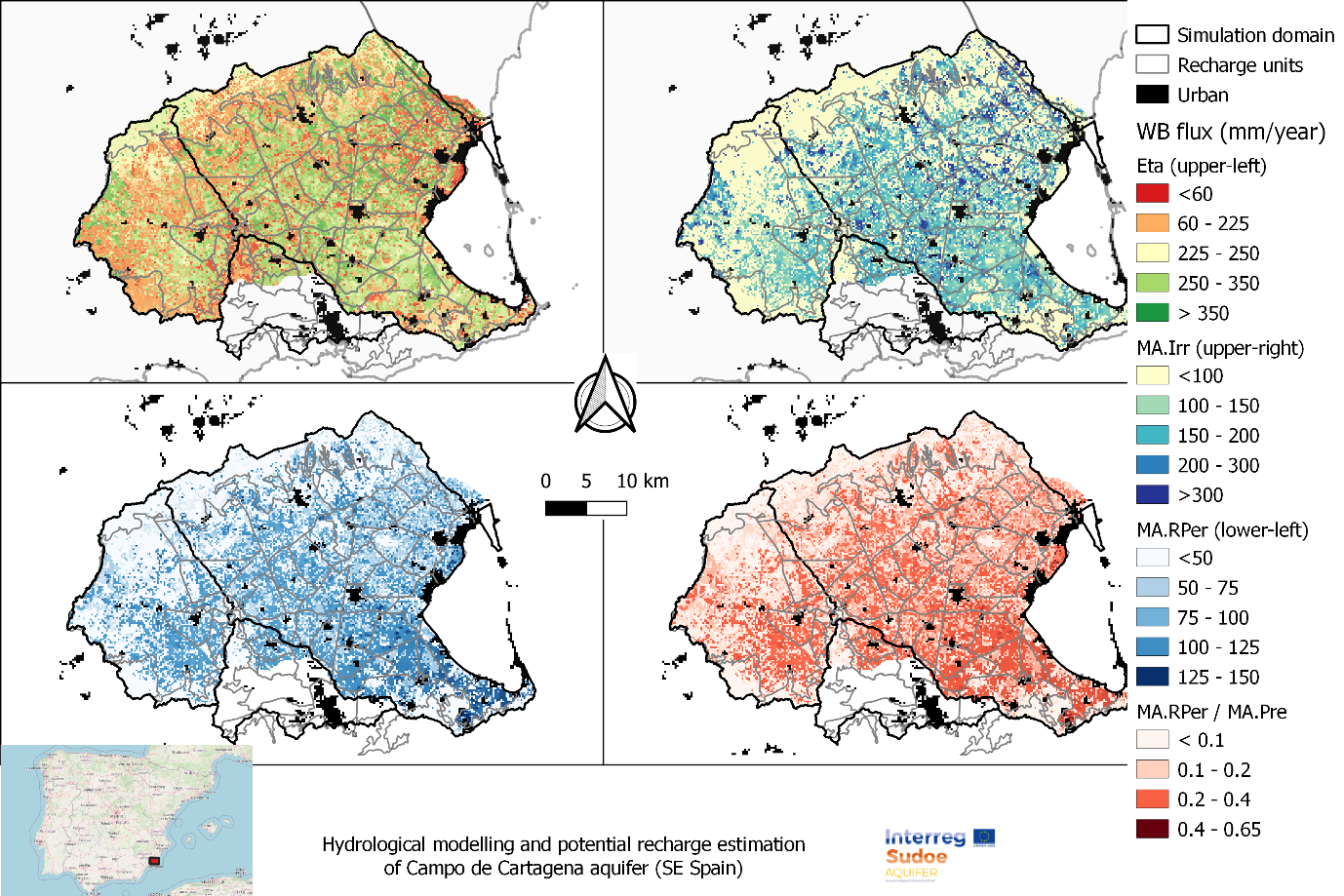
  • Producto 2. Base de datos climática regionalizada de alta resolución y de acceso libre.
  • Producto 3. Listado de estrategias de adaptación para la prevención y amortiguación de impactos, y el aumento de la seguridad hídrica y resiliencia de cuencas de alta montaña. Estos escenarios serán consensuados con agentes locales y partes interesadas, y su efectividad se evaluarán bajo escenarios extremos, no antes descritos pero plausibles, en tres cuencas piloto de alta montaña previamente seleccionadas por su representatividad, importancia estratégica y vulnerabilidad a las sequías.

En MegaWater, FutureWater coordina el paquete de trabajo para el desarrollo e implementación de herramientas de soporte a la decisión y adaptación a megasequías, incluyendo la organización de actividades con actores locales y partes interesadas para la priorización de intervenciones y puesta en común de resultados. El paquete de trabajo se organiza a través de dos actividades específicas: a) el desarrollo de un prototipo metodológico para cuantificación de impactos en cuencas vertientes y la identificación de puntos de inflexión para la seguridad hídrica, y b) el uso e integración de indicadores de estado de la criosfera en un sistema de alerta temprana, InfoSequia. como potenciales predictores de impacto y riesgo hídrico.

Representación esquemática de una cuenca de alta montaña, incluyendo los principales componentes, procesos e impactos relacionados con sequías.
Esquema del Sistema de Alerta Temprana InfoSequia desarrollado por FutureWater y adaptado para la detección de riesgos hídricos en cuencas de alta montaña. Más información sobre InfoSequia.

La ficha descriptiva de MegaWat se puede descargar aquí.

Agradecimientos

Este proyecto ha recibido financiación del programa Water4All con cofinanciación de CDTI y del Programa Marco de Investigación e Innovación «Horizonte Europa» de la Unión Europea”

Analysis of the historical climate data and future model projections indicates significant shifts in rainfall patterns. These shifts could influence water availability within the upstream river basins, which are vital for irrigation practices and ecological balance. Furthermore, the study explores variations in temperature -including average, minimum, and maximum values- and evaluates their potential consequences on water demand due to increased evaporation rates and altered crop water needs.

Additionally, this scoping research touches upon the effects of these climatic factors on olive crop phenology and productivity. The study also considers the likelihood of extreme weather events, such as heatwaves and droughts, and their potential to disrupt traditional farming cycles and water resource management strategies.

The outcomes of this analysis are aimed at providing an olive producing firm with insights and strategies to mitigate the adverse effects of climate change on olive production in these targeted regions of Andalucia. By foreseeing potential challenges and preparing for them, a decision can be made on whether to invest or not in order to maintain a leading olive producer on the global stage.

Southern Spain is a highly productive agricultural region, but with huge challenges around water scarcity and environmental sustainability. There is a demand in the agricultural sector to work towards water stewardship in Spain. The Alliance for Water Stewardship has developed a Standard which helps retailers and their suppliers to cause change at scale. This approach recognizes that there are common challenges that could be more easily overcome through a collective, place-based approach.

In the Doñana region, berry farms and groundwater usage are causing a conflict with the unique ecosystems in the National Park. A catchment assessment and active stakeholder engagement is needed as a first step in this region to work towards water stewardship. The catchment assessment will provide information on the catchment context, in line with the requirements of the Standard. The purpose of the assessment is to reduce the burden on agricultural sites by providing them with a common set of information which they and others can use to inform responses to their shared water challenges.

This consultancy project is framed by the AQUIFER project, “Innovative instruments for the integrated management of groundwater in a context of increasing scarcity of water resources” (Interreg-SUDOE V programme) which aims to capitalize, test, disseminate and transfer innovative practices for the preservation, monitoring and integrated management of aquifers.

FutureWater expertise was required for providing a novel and open-source hydrological modelling framework able to quantify spatial patterns of daily root percolation as a direct surrogate of groundwater recharge in the Campo de Cartagena Quaternary Aquifer (CC-QA). This aquifer is located at SE Spain and is one of the most important vectors of water drainage to the Mar Menor lagoon.

This task is addressed through the improvement and local calibration of the SPHY code for the Campo de Cartagena and the simulation of the water balance in the soil root zone from the 1950s until the end 2020. The SPHY-Campo de Cartagena includes a new routine able to compute irrigation inputs at the pixel level based on satellite data. Timeseries of monthly root percolation are taken as good surrogates of potential groundwater recharge and used as the main forcing input to an hydrogeological model of the Quaternary aquifer. The calibration process is performed through a sensititivity-intercomparison analysis in which model-derived outputs (irrigation and streamflow) during the calibration period are cross-checked against actual observations.

Spatial patterns of root percolation and the relative contribution of irrigation return flows to the total groundwater recharge were quantified (e.g. Figure 1) under historical and current conditions. Simulation results would show the lack of a significant temporal trend in the long-term recharge rates in the aquifer, most likely due to the the strong interannual variability observed in rainfall patterns, but also by the trade-offs resulting from the combination of climate, land use and irrigation-crop management drivers.

Figure 1. Mean Annual values of the main water balance components in Campo de Cartagena (2000-2020). RPer_ratio refers to the fraction between Root Percolation (MA.RPer) and Precipitation (MA.Pre)

FutureWater supports Fiera Comox in its due diligence process for the acquisition of a vertically integrated tree-fruit operation in North Spain. Particularly, FutureWater addresses an overall assessment of the most important water-related factors of risk that may control the current and medium-term feasibility of the fruit orchard farming system of interest. The application of FutureWater’s approach applies a multicriteria analysis and allows to qualify the levels of risk for each key factor analyzed.

FutureWater’s approach rests on: 1) the collection and analysis of data retrieved from documents, large datasets, and in-situ field inspections and stakeholder interviews, and 2) the scoring of the risks previously identified based on a final expert judgment.

Key sources of information for this risk screening included:

  • Existing documentation, reports, plans, and local legislation that may affect the access to water for irrigation
  • Existing and publicly accessible spatial and GIS data, including satellite imagery and thematic datasets available through national and regional agencies and platforms (Ebro River Basin Authority, National Infrastructure of Geospatial Data, Spanish Information System of Water)
  • Meteorological data (rainfall and temperature) from nearby weather stations
  • Groundwater level from the Spanish National Ministry of Environment.
  • Private data and documents generated by clients and stakeholders through personal and follow-up communications with farmer

Key variables analyzed and evaluated at the district and regional scales, to the extent relevant to the farm, included:

  • Water availability of surface and groundwater resources. For groundwater, a trend analysis of water levels, and first-order assessment of quality constraints and risks is included.
  • Impacts of climate change on water resources availability based on rainfall and temperature trends and projections for the region.
  • Water quality for irrigation purposes.
  • Potential conflicts due to competition for water in agriculture and other sectors of activity.

Legislative and policy-related factors that may affect the overall performance were also analyzed risk-by-risk.

Four factors of risk were analyzed: water availability, climate change, water quality, and water conflict. Each factor of risk was scored according to a risk matrix in which levels of probability of occurrence and impact severity were qualified based on data and expert judgement. For each factor, a risk matrix with three levels of overall risk were adopted: Low Risk (L), Moderate Risk (M), and High Risk (H)

Figure 1. Overall risk levels when probability of occurrence and impact severity are qualified.
Figure 2. Overview of risk assessment by factor.

In this particular project, the approach was implemented in four different settings located in the area.

The Mediterranean Region is facing growing challenges to ensure food and water supply as countries experience increasing demand and decreasing availability of natural resources. The nexus approach aims at managing and leveraging synergies across sectors with an efficient and integrated management of the Water, Energy, Food, and Ecosystems Nexus (WEFE).

BONEX objectives are to provide practical and adapted tools, examine concrete and context-adapted technological innovations, enhance policies and governance and facilitate WEFE Nexus practical implementation that balances the social, economic, and ecological trade-offs.

The project aims at producing a novel, transdisciplinary, diagnostic WEFE Bridging Framework, which combines methods in a context-specific manner and going beyond disciplinary silos. The diagnostic tools supporting the framework will be developed and tested in seven selected demonstration projects in the region which pilot innovative technologies (agrivoltaics, wastewater reuse systems, etc.).

As a result, BONEX will provide policymakers and practitioners with an interactive decision-making tool to evaluate trade-offs, synergies, and nexus solutions approaches in a transdisciplinary manner. Further, it will produce valuable experiences with tailoring innovative WEFE Nexus technologies that provides new business opportunities. The WEFE nexus approach is required to implement sustainable agri-food systems and preserve ecosystems.

Within BONEX FutureWater will actively contribute to the package of diagnostic tools. A simple water accounting tool (REWAS) will be used to evaluate if ‘Real Water Savings’ are achieved with innovative technologies. The water accounting tool evaluates water flows at field level and irrigation district scale and determines if any ‘real savings’ are achieved. The tool also incorporates the aspects of food production (crop yield) and will introduce components for evaluating energy and water quality aspects to complement the WEFE Nexus aspects. The seven demonstration projects will be used to demonstrate and iteratively develop this water accounting tool. A hydrological analysis is performed in selected locations to also evaluate the impact at basin (watershed) scale. Eventually the results from these analyses will be translated into policy implications and achievements of SDG’s (sustainable development goals).

This project is part of the PRIMA programme supported by the European Union.

Water and food security are at risk in many places in the world: now and most likely even more in the future, having large economic and humanitarian consequences. Risk managers and decision-makers, such as water management authorities and humanitarian-aid agencies/NGOs, can prevent harmful consequences more efficiently if information is available on-time on (1) the impact on the system, economy or society, and also (2) the probabilities for a failure in the system. EO information has proven to be extremely useful for (1). For looking into the future, considering the uncertainties, novel machine learning techniques are becoming available.

The proposed development is incorporated into an existing solution for providing Drought and Early Warning Systems (DEWS), called InfoSequia. InfoSequia is a modular and flexible toolbox for the operational assessment of drought patterns and drought severity. Currently, the InfoSequia toolbox provides a comprehensive picture of current drought status, based mainly on EO data, through its InfoSequia-MONITOR module. The proposed additional module, called InfoSequia-4CAST, is a major extension of current InfoSequia capabilities, responding to needs that have been assessed in several previous experiences.

InfoSequia-4CAST provides the user with timely, future outlooks of drought impacts on crop yield and water supply. These forecasts are provided on the seasonal scale, i.e. 3-6 months ahead. Seasonal outlooks are computed by a novel state-of-the-art Machine Learning technique. This technique has already been tested for applications related to crop production forecasting and agricultural drought risk financing. The FFTrees algorithm uses predictor datasets (in this case, a range of climate variability indices alongside other climatic and vegetative indices) to generate FFTs predicting a binary outcome – crop yields or water supply-demand balance above or below a given threshold (failure: yes/no).

The activity includes intensive collaboration with stakeholders in Spain, Colombia and Mozambique, in order to establish user requirements, inform system design, and achieve pilot implementation of the system in the second project year. Generic machine learning procedures for training the required FFTs will be developed, and configured for these pilot areas. An intuitive user interface is developed for disseminating the output information to the end users. In addition to development of the forecasting functionality, InfoSequia-MONITOR will be upgraded by integrating state-of-the art ESA satellite data and creating multi-sensor blended drought indices.

El proyecto Grupo Operativo ECOPRADERAS financiado por EIP-AGRI , tiene como objetivo general mejorar el manejo y la gestión de las praderas mediante: (1) la transferencia e implementación de tecnologías innovadoras, (2) la identificación y fortalecimiento de buenas prácticas culturales, y (3) la difusión de la información y los resultados más relevantes entre los usuarios finales. FutureWater asiste a ECOPRADERAS en lo referido al primer apartado, mediante el encargo específico de desarrollar una herramienta para el seguimiento operacional del estado de las praderas del Valle del Alagón mediante el uso combinado de índices espacio-temporales de satélite.

La metodología empleada por FutureWater utiliza tecnologías de procesamiento masivo de datos en la nube (Google Earth Engine) para calcular un índice cualitativo de estado de la superficie que combina valores de anomalía espacial y temporal del indice de verdor (NDVI). Este indice cualitativo de estado permite categorizar el territorio en diferentes clases y detectar trayectorias o prácticas de manejo pascícola que suponen un riesgo para la sostenibilidad ambiental del sistema productivo y que necesitarían de especial atención.

Las tareas del proyecto incluyen la definición del esquema metodológico, el diseño e implementación de una plataforma web-mapping, y la calibración-validación de los resultados mediante comparación con datos de campo obtenidos en fincas piloto y proporcionados por los socios del proyecto.

Monitor Ecopraderas implementado en el Valle del Alagón (España)

Groundwater is one of the most important freshwater resources for mankind and for ecosystems. Assessing groundwater resources and developing sustainable water management plans based on this resource is a major field of activity for science, water authorities and consultancies worldwide. Due to its fundamental role in the Earth’s water and energy cycles, groundwater has been declared as an Essential Climate Variable (ECV) by GCOS, the Global Climate Observing System. The Copernicus Services, however, do not yet deliver data on this fundamental resource, nor is there any other data source worldwide that operationally provides information on changing groundwater resources in a consistent way, observation-based, and with global coverage. This gap will be closed by G3P, the Global Gravity-based Groundwater Product.

The G3P consortium combines key expertise from science and industry across Europe that optimally allows to (1) capitalize from the unique capability of GRACE and GRACE-FO satellite gravimetry as the only remote sensing technology to monitor subsurface mass variations and thus groundwater storage change for large areas, (2) incorporate and advance a wealth of products on storage compartments of the water cycle that are part of the Copernicus portfolio, and (3) disseminate unprecedented information on changing groundwater storage to the global and European user community, including European-scale use cases of political relevance as a demonstrator for industry potential in the water sector. In combination, the G3P development is a novel and cross-cutting extension of the Copernicus portfolio towards essential information on the changing state of water resources at the European and global scale. G3P is timely given the recent launch of GRACE-FO that opens up the chance for gravity-based time series with sufficient length to monitor climate-induced and human-induced processes over more than 20 years, and to boost European space technology on board these satellites.

In this project, FutureWater is in charge of a case which aims to prototype and calibrate a Groundwater Drought Index based on the G3P product, and to integrate it into InfoSequia, the FutureWater’s in-house Drought Early Warning System. The new InfoSequia component will be tested for inherent reliability and flexibility at the basin level in a total area of about 145 000 km2 in Southern Spain which largely relies on groundwater resources. This pilot region comprises three large basins (Segura, Guadalquivir and Guadiana) with many aquifers and groundwater bodies where very severe dynamics of overexploitation and mining have been identified and declared. Unsustainable groundwater development threats the water security in the region, but also the ecological status and preservation of unique and highly protected ecosystems in Europe (e.g., Doñana National Park, Daimiel National Park, Mar Menor coastal lagoon).

To visit the official G3P website, please click on this link: https://www.g3p.eu

Descripción del Proyecto

La descarga subterránea procedente de los retornos de riego de origen agrícola hacia el Mar Menor se encuentra entre una de las posibles causas que explicarían los altos niveles de eutrofización (hipereutrofización) y elevada proliferación de algas alcanzados en este ecosistema lagunar. Estudios previos, liderados y/o participados por FutureWater (Contreras et al., 2014; Jiménez-Martínez et al., 2017), apuntan a que las aportaciones subterráneas al Mar Menor alcanzarían valores muy superiores a las cifras oficialmente reconocidas.

Una de las alternativas planteadas para reducir las aportaciones subterráneas y de nutrientes al Mar Menor consiste en la creación de una red de drenajes superficiales y subsuperficiales que permita la captación de la descarga subterránea en las proximidades de la laguna (Figura 1), y que tras un adecuado tratamiento de desalinización y desnitrificación, podría reutilizarse para riego agrícola. Este tipo de infraestructuras de captación están actualmente operativas en el ámbito de la CCRR Arco Sur – Mar Menor.


Figura: Flujos y relación entre el acuifero cuaternario del Campo de Cartagena y el Mar Menor sin (izquierda) y con (derecha) un sistema de drenaje superficial.

La CCRR Arco-Sur ha encargado a FutureWater, en colaboración con Hydrogeomodels, el este proyecto con el objeto de evaluar la utilidad de estas infraestructuras y explorar las posibilidades de extenderlas hacia el resto del Campo de Cartagena. El uso de modelos matemáticos para simular la dinámica del flujo subterráneo en el acuífero y el patrón espacial de descarga permitirían demostrar la eficacia de estas infraestructuras, y explorar cuáles son las mejores ubicaciones y regímenes de explotación para reducir las descargas al Mar Menor sin comprometer la sostenibilidad ambiental de los humedales costeros.

El desarrollo y calibración del modelo hidrogeológico del acuífero cuaternario del Campo de Cartagena se ha basado en la recopilación intensiva de los datos disponibles hasta la fecha, y la integración de las técnicas de simulación hidrológica e hidrogeológica más avanzadas. El modelo hidrogeológico del Campo de Cartagena es una herramienta clave para apoyar la toma de decisiones y evaluar la efectividad de diferentes estrategias de explotación (batería de bombeos, redes de drenaje), o los impactos asociados a cambios de uso del suelo o del clima.

Objetivo y Metodología

El objetivo de este estudio es cuantificar el patrón espacial del balance de agua en el Campo de Cartagena, la dinámica del flujo de agua subterránea en el acuífero cuaternario superficial, y el patrón espacial de descarga subterránea al Mar Menor para condiciones hidrológicas promedio y extremas, mediante la calibración e implementación de un modelo hidrogeológico.

El proyecto se ha ejecutado en cuatro fases (Figura 2): 1) recopilación y preparación de datos de entrada, 2) modelación hidrológica, 3) modelación hidrogeológica, y 4) documentación y actividades de divulgación.

Figura: Diagrama metodológico y fases de ejecución.

Principales resultados del estudio

  1. El volumen de recarga anual del acuífero superficial Cuaternario se estima entre 12 hm3/año en periodos muy secos, y 200 hm3/año en periodos muy húmedos. El valor promedio anual se estima en 74 hm3/año.
  2. El volumen de descarga potencial al Mar Menor, sin contar las extracciones por bombeo en pozos y drenes, ni tampoco las transferencias de agua hacia capas inferiores del acuífero, se ha estimado entre los 63 y 83 hm3/año, siendo el valor medio estimado de 71 hm3/año.
  3. La descarga real promedio al Mar Menor durante el periodo de simulación (2001-2016) se ha estimado entre 38 hm3/año y 46 hm3/año. Estos valores oscilan ±10 hm3/año, según se consideren años húmedos o secos.
  4. La mayor parte de la descarga al Mar Menor se concentra en los sectores próximos a la Rambla del Albujón y al norte del Campo de Cartagena. La descarga en el ámbito de actuación de la Comunidad de Regantes Arco Sur es muy reducida habiéndose estimado en no más del 5% del volumen total descargado.

Infografía y vídeo

Enlace a la presentación pública del estudio.

La noticia en los medios de comunicación: