A través de una interfaz web fácil de usar y de servicios de datos interoperables, DROPS-WISE facilitará la toma de decisiones operativas, la gestión de crisis y la planificación a largo plazo para las autoridades responsables del agua y otras partes interesadas. Diseñada teniendo como pilares fundamentales la interoperabilidad, la gobernanza de datos y la escalabilidad, la solución se ajusta a las normas europeas en materia de datos y a los servicios de Copernicus, contribuyendo a una gestión del agua más resiliente y basada en datos ante la creciente incertidumbre climática.
DROPS-WISE es uno de los cinco consorcios seleccionados en el marco del proyecto de innovación PCP WISE. PCP WISE es un proyecto de innovación europeo en el que colaboran organizaciones públicas y agentes del mercado de toda Europa. El proyecto se centra en el desarrollo de una herramienta útil y aplicable para la información sobre el agua, que permita a los gestores del agua responder mejor y más rápidamente a los retos relacionados con el clima. Al combinar de forma inteligente los datos satelitales con, por ejemplo, mediciones de campo y modelos meteorológicos e hidrológicos, se obtiene una mayor comprensión de la dinámica del sistema de vegetación acuática.
DROPS-WISE está formado por un consorcio entre FutureWater, Acacia Water, Nelen & Schuurmans, VITO, Technolution y ARUP. FutureWater aporta su experiencia en modelización y análisis hidrológicos, evaluación de riesgos y gestión de la escasez de agua y la sequía.
El apoyo técnico se basa en la modelización de los recursos hídricos, la alerta temprana de sequías y la teledetección, así como en la colaboración con instituciones del conocimiento y responsables políticos. El trabajo también incluye la evaluación de las prácticas actuales en los Estados miembros, la evaluación de los impactos ecológicos y socioeconómicos y la identificación de áreas de mejora. Con esta aportación, FutureWater ayuda a la Comisión a abordar cuestiones complejas relacionadas con la capacidad de recuperación del agua, garantizando al mismo tiempo que los resultados científicos se traduzcan en ideas prácticas para la política y la planificación.
La mayoría de las investigaciones recientes se han centrado en la identificación de episodios históricos basados en paleoregistros y la comprensión de sus causas climáticas, o en el estudio de megasequías “modernas” y sus impactos, generalmente en cuencas bajas y llanuras. Sin embargo, las cuencas de montaña han sido poco estudiadas y poco se sabe sobre el impacto de las megasequías en el estado y dinámica de la criosfera o torres de agua de montaña. Las cuencas vertientes dependientes de sistemas de alta montaña disponen de una capacidad para amortiguar la falta de precipitaciones y exceso de evapotranspiración que depende de las reservas de agua proporcionadas por la criosfera (nieve, glaciares y permafrost). Se presume, que la capacidad de amortiguación es limitada hasta alcanzar un punto de inflexión donde los impactos de la falta de agua y temperaturas extremas pueden verse amplificados y poner en peligro el funcionamiento del ecosistema hídrico.
MegaWat tiene un doble objetivo: 1) abordar las lagunas de conocimiento entorno a las causas hidroclimáticas de las sequías extremas y su impacto en el balance del agua de las torres de agua de montaña de Europa, haciendo especial énfasis en la concurrencia de eventos compuestos y los efectos en cascada y multiescala, y 2) desarrollar y proponer nuevas estrategias de adaptación para hacer frente a la duración, extensión e intensidad de futuras megasequías y sus impactos ambientales y socioeconómicos.
Para su implementación, MegaWat se centra en los sistemas de alta montaña de Europa y sus cuencas vertientes. MegaWat ambiciona el desarrollo de tres productos:
Producto 1. Marco metodológico para la identificación y caracterización de megasequías históricas durante el periodo instrumental, y la evaluación del papel que juega la criosfera en la amortiguación de los impactos del cambio climático y el desarrollo territorial en las cuencas vertientes. El producto 1 descansa en la combinación de herramientas de regionalización climática, modelización del balance de energía en superficie, simulación hidrológica, y códigos de evaluación y asignación optimización de recursos hídricos.
Producto 2. Base de datos climática regionalizada de alta resolución y de acceso libre. (ver figura)
Producto 3. Listado de estrategias de adaptación para la prevención y amortiguación de impactos, y el aumento de la seguridad hídrica y resiliencia de cuencas de alta montaña. Estos escenarios serán consensuados con agentes locales y partes interesadas, y su efectividad se evaluarán bajo escenarios extremos, no antes descritos pero plausibles, en tres cuencas piloto de alta montaña previamente seleccionadas por su representatividad, importancia estratégica y vulnerabilidad a las sequías.
Representación esquemática de una cuenca de alta montaña, incluyendo los principales componentes, procesos e impactos relacionados con sequías.
En MegaWater, FutureWater coordina el paquete de trabajo para el desarrollo e implementación de herramientas de soporte a la decisión y adaptación a megasequías, incluyendo la organización de actividades con actores locales y partes interesadas para la priorización de intervenciones y puesta en común de resultados. El paquete de trabajo se organiza a través de dos actividades específicas: a) el desarrollo de un prototipo metodológico para cuantificación de impactos en cuencas vertientes y la identificación de puntos de inflexión para la seguridad hídrica, y b) el uso e integración de indicadores de estado de la criosfera en un sistema de alerta temprana, InfoSequia. como potenciales predictores de impacto y riesgo hídrico. (ver figura)
Esquema del Sistema de Alerta Temprana InfoSequia desarrollado por FutureWater y adaptado para la detección de riesgos hídricos en cuencas de alta montaña. Más información sobre InfoSequia.
La ficha descriptiva de MegaWat se puede descargar aquí.
Agradecimientos
Este proyecto ha recibido financiación del programa Water4All con cofinanciación de CDTI y del Programa Marco de Investigación e Innovación Horizonte Europa de la Unión Europea.
Groundwater is one of the most important freshwater resources for mankind and for ecosystems. Assessing groundwater resources and developing sustainable water management plans based on this resource is a major field of activity for science, water authorities and consultancies worldwide. Due to its fundamental role in the Earth’s water and energy cycles, groundwater has been declared as an Essential Climate Variable (ECV) by GCOS, the Global Climate Observing System. The Copernicus Services, however, do not yet deliver data on this fundamental resource, nor is there any other data source worldwide that operationally provides information on changing groundwater resources in a consistent way, observation-based, and with global coverage. This gap will be closed by G3P, the Global Gravity-based Groundwater Product.
The G3P consortium combines key expertise from science and industry across Europe that optimally allows to (1) capitalize from the unique capability of GRACE and GRACE-FO satellite gravimetry as the only remote sensing technology to monitor subsurface mass variations and thus groundwater storage change for large areas, (2) incorporate and advance a wealth of products on storage compartments of the water cycle that are part of the Copernicus portfolio, and (3) disseminate unprecedented information on changing groundwater storage to the global and European user community, including European-scale use cases of political relevance as a demonstrator for industry potential in the water sector. In combination, the G3P development is a novel and cross-cutting extension of the Copernicus portfolio towards essential information on the changing state of water resources at the European and global scale. G3P is timely given the recent launch of GRACE-FO that opens up the chance for gravity-based time series with sufficient length to monitor climate-induced and human-induced processes over more than 20 years, and to boost European space technology on board these satellites.
In this project, FutureWater is in charge of a case which aims to prototype and calibrate a Groundwater Drought Index based on the G3P product, and to integrate it into InfoSequia, the FutureWater’s in-house Drought Early Warning System. The new InfoSequia component will be tested for inherent reliability and flexibility at the basin level in a total area of about 145 000 km2 in Southern Spain which largely relies on groundwater resources. This pilot region comprises three large basins (Segura, Guadalquivir and Guadiana) with many aquifers and groundwater bodies where very severe dynamics of overexploitation and mining have been identified and declared. Unsustainable groundwater development threats the water security in the region, but also the ecological status and preservation of unique and highly protected ecosystems in Europe (e.g., Doñana National Park, Daimiel National Park, Mar Menor coastal lagoon).
To visit the official G3P website, please click on this link: https://www.g3p.eu
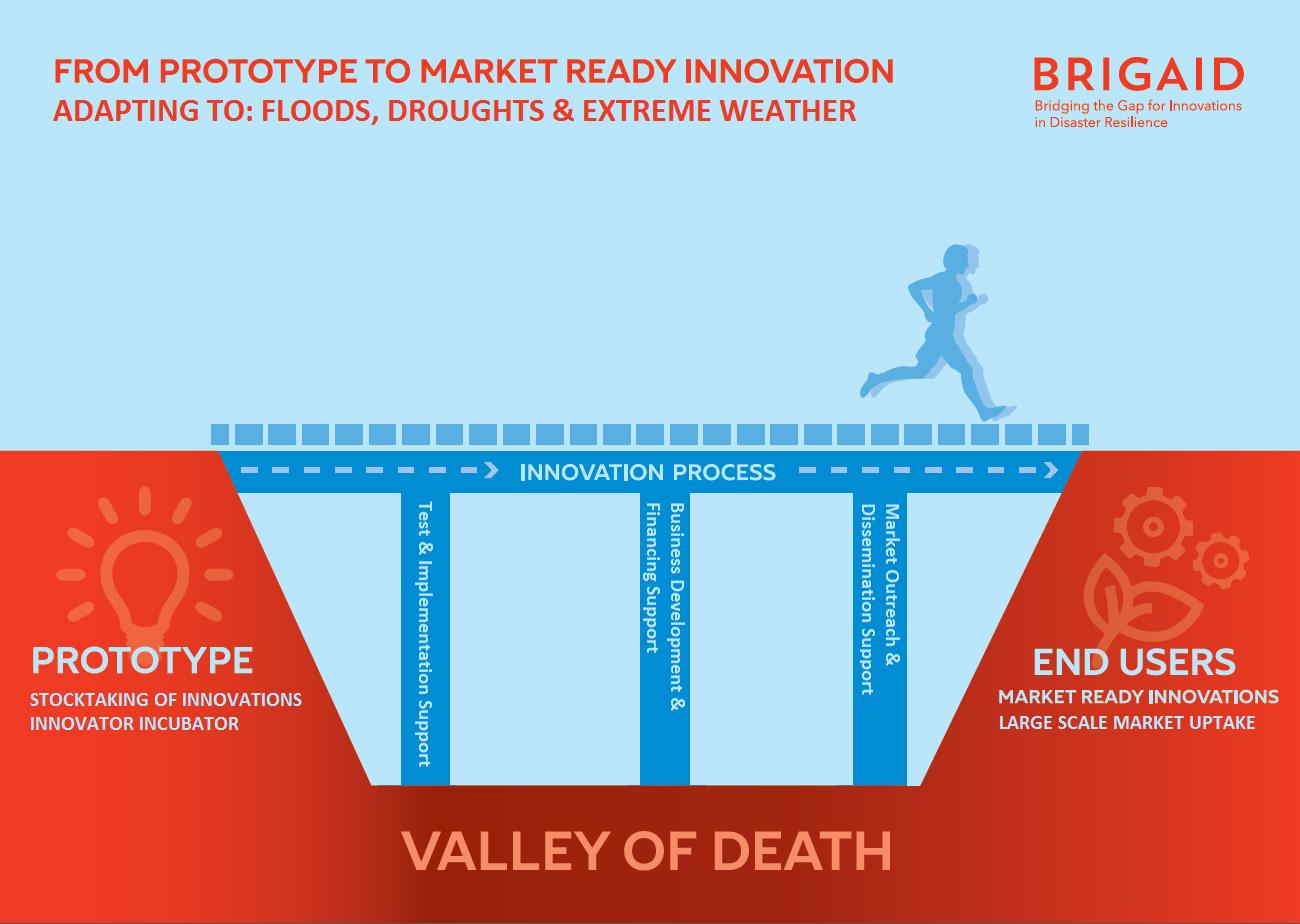
Los estudios publicados recientemente por el Panel Intergubernamental del Cambio Climático (IPCC) indican que Europa estará sometida a un mayor número de eventos hidroclimáticos extremos (inundaciones, sequías, olas de calor e incendios forestales). Sin embargo, estos estudios también identifican un gran potencial para que la comunidad científica, inversores y las empresas innoven, impulsen e implementen estrategias y soluciones para la adaptación al cambio climático que minimicen los riesgos asociados a este tipo de eventos. A pesar de estas oportunidades, muchas de estas innovaciones corren el riesgo de no poder ser implementadas en el mercado de manera efectiva. BRIGAID tiene como misión servir de puente para la innovación y ayudar a que los prototipos puedan alcanzar el mercado con ciertas garantías de éxito.
BRIGAID se apoya en tres pilares fundamentales:
– El reconocimiento de la variabilidad geográfica de los riesgos relacionados con el clima y su interacción con los cambios socioeconómicos,
– El apoyo continuo a las innovaciones-prototipo (nivel de madurez de 3-4) que estén en disposición de ser validadas en un entorno experimental y operativo.
– El desarrollo de un marco estandarizado e independiente para el testeo y evaluación de la eficacia socio-tecnológica de una innovación.
Aproximación conceptual de BRIGAID. BRIGAID favorece la inserción exitosa de prototipos en el mercado mediante la adopción de herramientas estandarizadas de evaluación operacional, desarrollo de planes de negocio y la adopción de estrategias de comunicación y diseminación.
BRIGAID tiene como objetivos: (a) servir de nexo entre innovadores, inversores, y clientes y usuarios finales entorno a Comunidades de Innovación que incrementen las oportunidades de éxito de las innovaciones introducidas en el mercado; (b) contribuir al desarrollo de una metodología estándar que permita la valoración objetiva de las capacidades tecnológicas y la aceptabilidad social de una innovación mediante su testeo en ambientes de simulación propios; c) mejorar la capacidad de innovación y la integración de diferentes soluciones tecnológicas a través de redes de innovación; (d) reforzar la competitividad y el crecimiento de las empresas con el apoyo de un equipo de expertos en análisis de mercado, y planes de negocio y comunicación. Finalmente, BRIGAID tiene como ambición crear un marco de comunicación y financiación público-privado que facilite la conexión entre los innovadores e los inversores.
FutureWater contribuye en BRIGAID como: a) coordinador del paquete de trabajo de “Innovaciones para la adaptación a las Sequías” en el que se identificarán, describirán y evaluarán al menos 30 soluciones tecnológicas desarrolladas a nivel europeo; b) agente innovador mediante el desarrollo y testeo de Sistemas de Soporte a la Decisión para el seguimiento y gestión eficiente de las sequías (multiherramienta GEISEQ), y la detección temprana de anomalías de rendimiento de cultivos mediante la integración de información de alta precisión procedente de vehículos áereos no tripulados o UAVs y herramientas de modelización agrohidrológica (plataforma AGROFLY).
Presentación del proyecto
System-Risk is a Marie-Skłodowska-Curie European Training Network which aims on developing and implementing a systems approach for large-scale flood risk assessment and management and provides a framework for training and career development of 15 Early Stage Researchers (ESRs).
Particularly, national and regional policy development adhering to the solidarity principle anchored in the European Flood Directive as well as the insurance industry require tools to assess and manage flood risk at large scales, from the larger river basin to the European scale. Yet, the majority of flood research has centered on small- to meso-scale catchments and, to date, such requirements have usually been addressed by piecing together small-scale solutions. Today, increased data availability, new numerical algorithms and dramatically higher computer performance enable large-scale analyses and modelling which were not feasible a few years ago.
System-Risk performs leading-edge research with spotlights on three essential pillars of flood risk research:
Risk chain: considering the complete risk chain from the Sources through the Pathways to the Receptors and Consequences.
Interactions: augmenting the ‘Source-Pathway-Receptors and Consequences‘ model by putting interactions centre stage and, in this way, replacing the traditional linear approach of the risk chain by a more realistic approach with interdependent linkages between physical and societal processes which finally shape the spatio-temporal flood risk.
Temporal dynamics: investigating the time-varying nature of flood risk and its components on different time scales as for instance hours to days when flood defense failures change flood probabilities, months to years when people learn from damaging floods and improve private precaution and decades to centuries when human settlements in floodplains evolve.
System-Risk is composed of 15 Early Stage Research Projects (ESRs) organized in three scientific work packages complemented by training, dissemination and management. These WPs are:
Atmosphere-Catchment-System (WP1)
River-Dike-Floodplain System (WP2)
Socio-Economic System (WP3)
System-Risk brings together research and training at ten leading centres of flood research in Europe and embeds partnerships with eight partners from the industry and administration in five countries.
In collaboration with the Royal Meteorological Institute (KNMI), FutureWater will be the hosting institute for ESR1, which is part of WP1. This ESR will focus on the “Development of Future Weather techniques for flood risk assessment”. The ESR shall focus on the interplay between meteo- and hydrological factors leading to extreme floods under present and future climate. It is expected that the ESR will develop methods and tools for deriving consistent, large-scale flood scenarios and quantifying their uncertainty. The developed methods and tools will be validated for three case-study basins.
The recently released fourth assessment report of the Intergovernmental Panel on Climate Change predicts and ongoing warming trend in Europe. Specifically Southern Europe as well as the Mediterranean region are likely to suffer from prolonged drought spells in summer in the decades ahead. The Royal Netherlands Meteorological Institute (KNMI) also predicts that droughts will be more regularly manifested at the northern latitudes. The climate scenarios suggest that drier summers will plague Western Europe, intermitted by wetter winter seasons. At the European scale water shortages and drought also receive increasingly more attention. The EU water framework directive, as well as other EU water policy documents, are all based on sufficient per capita water availability and of water of good quality.
Over the last decade, various tools based on Remote Sensing (RS) techniques from satellites to assist land management have been developed. The EU is working on standard products for land; including an EU land cover map (e.g. Corine, Pelcom), crop yield forecasting (CGMS) and soil erosion. Yet, there are no real products dedicated for water management applications, In the early days of RS, images were mainly used qualitatively, but the increase in accuracy of sensors and especially a better understanding of processes, have evolved in the development of quantitative algorithms to convert raw data into useful information. In recent years an increasing number of Remotely Sensed datasets and algorithms relevant to water managers have emerged. It is now feasible to quantify (i) evapotranspiration and top soil moisture, (ii) precipitation and (iii) changes in groundwater storage based on RS. This project upgrades these research algorithms to an operational water management product.