To facilitate the needs of ZIPAK, this training aims to build data-driven capacities relevant to sustainable nature conservation practices and ecosystem-based natural resources management in Iran:
Leveraging the Climate Change Knowledge Portal (CCKP) for performing climate risk and vulnerability assessments
Leveraging the online dashboard Earth Map for environmental hazard mapping and socio-economic risk assessments
Applying the InVest model (Integrated Valuation of Ecosystem Services and Tradeoffs) for assessing ecosystem service provision
The training focuses on knowledge and skills development and how how to meaningfully integrate these capabilities into ZIPAK’s objectives on sustainable management of the environment and natural resources.
In irrigated agriculture options to save water tend to focus on improved irrigation techniques such as drip and sprinkler irrigation. These irrigation techniques are promoted as legitimate means of increasing water efficiency and “saving water” for other uses (such as domestic use and the environment). However, a growing body of evidence, including a key report by FAO (Perry and Steduto, 2017) shows that in most cases, water “savings” at field scale translate into an increase in water consumption at system and basin scale. Yet despite the growing and irrefutable body of evidence, false “water savings” technologies continue to be promoted, subsidized and implemented as a solution to water scarcity in agriculture.
The goal is to stop false “water savings” technologies to be promoted, subsidized and implemented. To achieve this, it is important to quantify the hydrologic impacts of any new investment or policy in the water sector. Normally, irrigation engineers and planners are trained to look at field scale efficiencies or irrigation system efficiencies at the most. Also, many of the tools used by irrigation engineers are field scale oriented (e.g. FAO AquaCrop model). The serious consequences of these actions are to worsen water scarcity, increase vulnerability to drought, and threaten food security.
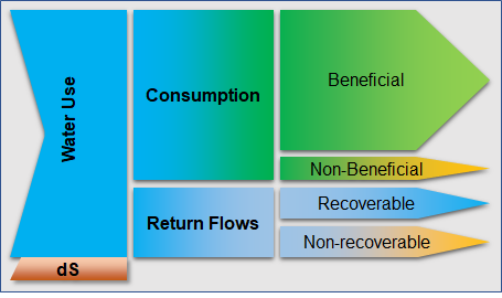
There is an urgent need to develop simple and pragmatic tools that can evaluate the impact of field scale crop-water interventions at larger scales (e.g. irrigation systems and basins). Although basin scale hydrological models exist, many of these are either overly complex and unable to be used by practitioners, or not specifically designed for the upscaling from field interventions to basin scale impacts. Moreover, achieving results from the widely-used FAO models such as AquaCrop into a basin-wide impact model is time-consuming, complex and expensive. Therefore, FutureWater is developing a simple but robust tool to enhance usability and reach, transparency, transferability in data input and output. The tool is based on proven concepts of water productivity, water accounting and the appropriate water terminology, as promoted by FAO globally (FAO, 2013). Hence, the water use is separated in consumptive use, non-consumptive use, and change in storage (Figure 1).
Separation of water use according to the FAO terminology.
A complete training package is developed which includes a training manual and an inventory of possible field level interventions. The training manual includes the following aspects: 1) introduce and present the real water savings tool, 2) Describe the theory underlying the tool and demonstrating some typical applications, 3) Learn how-to prepare the data required for the tool for your own area of interest, 4) Learn when real water savings occur at system and basin scale with field interventions.
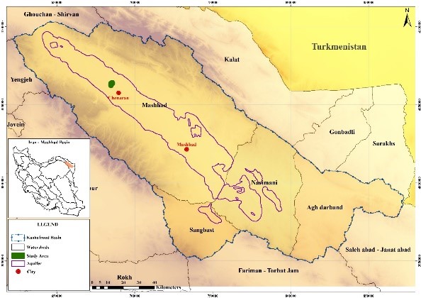
The Mashhad city is the second largest city in Iran. The economic growth in the Mashhad city is strongly threatened by water shortages and unregulated groundwater extraction. The situation is critical, and the government is considering drastic infrastructural measures such as desalination and water supply from the Sea of Oman (Ministerie van Landbouw, 2018). Hence, finding cost-effective alternatives to reduce groundwater consumption in the Mashhad basin (Figure 1) is of regional interest.
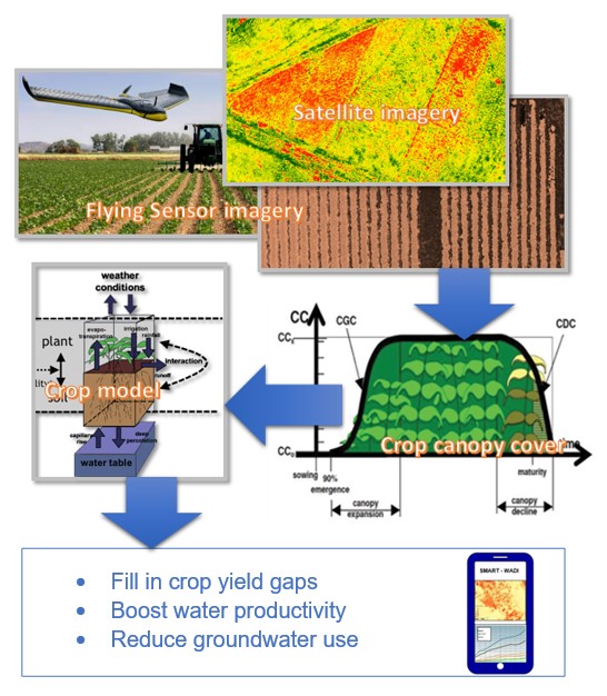
The SMART-WADI project (SMART Water Decisions for Iran), carried out by a consortium of FutureWater, IHE-Delft, and local partner EWERI, focuses on farmers who irrigate their crops with groundwater. The aim is to provide up-to-date information and advice on water productivity, irrigation and farm management. The project combines the latest satellite technology for the quantification of water consumption and productivity, with high resolution flying sensor (drone) images to monitor the crop growth.
Figure 1. Mashhad basin in Iran.
Using this information in a crop model can determine the potential for improving agricultural practices and reduce groundwater consumption. This way, a higher crop yield (food production) and higher water productivity can be obtained (Figure 2). Eventually farmers receive this information in combination with recommendations regarding irrigation planning via an online portal or mobile app.
SMART-WADI is now in the phase of a feasibility project, in which the market context and technical aspects are tested. This is supported by the Partners for Water Program of RVO.nl, with co-funding from the executive project partners. Based on the first signals and the experiences of FutureWater and IHE-Delft in similar projects, it is estimated that this information service has great potential to be scaled up to other areas in Iran.
FutureWater is developing and testing a framework to predict crop yield and water productivity based on crop growth monitoring using flying sensors and remote sensing. Thanks to this innovation, farmers can timely plan field management practices (e.g. irrigation application) enhancing water productivity and reducing groundwater consumption.
Figure 2. Conceptual framework of SMART-WADI.
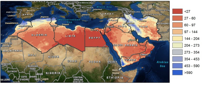
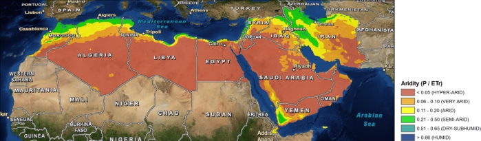
The Middle East and North Africa (MENA) region is considered the most water-scarce region of the world. Disputes over water lead to tension within communities, and unreliable water services are prompting people to migrate in search of better opportunities. Water investments absorb large amounts of public funds, which could often be used more efficiently elsewhere. As the region’s population continues to grow, per capita water availability is set to fall by 50 percent by 2050, and, if climate change affects weather and precipitation patterns as predicted, the MENA region may see more frequent and severe droughts and floods
Map of yearly average precipitation in the MENA region (mm).
The need for alternative and improved water management options is therefore urgently needed, but a clear overview on what the main focus should be is lacking. A broad range of options exists which can be grouped by different approaches such as reducing the demand, increasing the supply, transfer between different sectors, transfer within different sectors, increase storage etc. An important aspect for the MENA region includes desalination.
Map of aridity in the MENA region.
To explore different options the World Bank initiated an initiative to generate an improved understanding of water issues in the region and overview of available options under different scenarios of water supply and demand management with special focus on desalination, taking into account the energy nexus and environmental concerns. As part of this initiative, FutureWater will carry out an assessment of water stress in the MENA region, including associated marginal cost of water supply to meet the water supply need. Conducting consultation workshops and meetings will be organized with relevant parties in the region (governmental, universities, civil society groups).