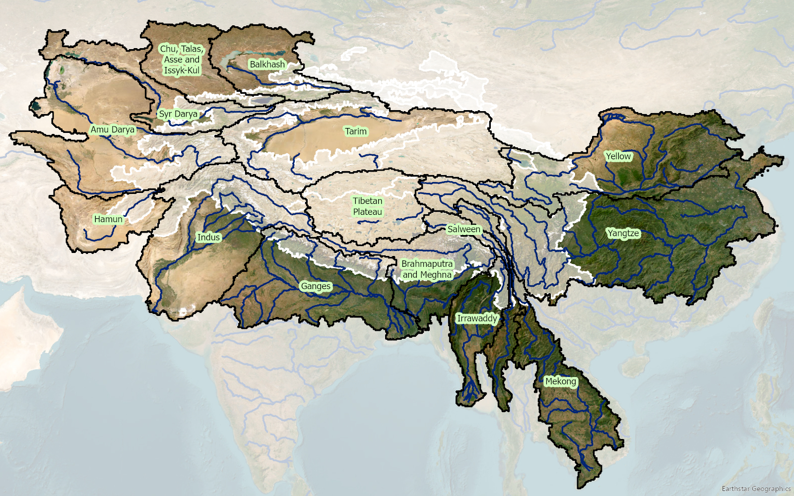
The alarming decline of springs has been attributed to the rapid expansion of road networks, alongside changes in land cover and climate. Road development in these areas exposes springs to disturbances or alters their natural outflow, while rock cutting disrupts the location of spring orifices. This problem has largely gone unnoticed, posing a significant threat to the local communities and their water resources.

The overarching goal of the project is to reimagine roads as instruments for landscape improvement rather than adversaries, harnessing road development to contribute positively to local water resources. By integrating techniques and tools (Digital twins and DSS toolkit), the project aims to ensure safe and reliable water supplies for people in mountain areas while safeguarding the quality of road infrastructure and maintaining connectivity. The Dhankuta municipality and the Department of Local Infrastructure (DoLI), which regulates infrastructure development activities in Nepal, will be the primary beneficiaries of this project.

The expected results of the RoSPro project include:

  1. Successful implementation of roadside spring protection through pilot interventions in Dhankuta municipality and promote “Nature-based solutions” and “Green Roads for Water (GR4W)” approaches.
  2. Evidence generation on the impact of the pilot intervention through cost-benefit analysis.
  3. Assessment of the potential impact of upscaling roadside spring protection through the development of a digital twin and decision support toolkit.
  4. Capacity building for Dhankuta municipality and DoLI regarding roadside spring protection approaches, technologies, impact, and upscaling.

RoSPro will lead to improved water security for consumptive and productive uses, directly benefiting up to 500 households in the region. Following the pilot phase, the project aims to expand its services to established clients and partner networks in Asia and Africa. The demand for similar services is high in many high mountain countries, and RoSPro aims to generate a framework to upscale this at national and regional scales.

Thus, the RoSPro is a vital initiative that seeks to address the critical issue of dwindling springs in the Himalayas. By transforming road development into a contributor to local water resources, RoSPro will improve water safety and security, benefiting both the communities and the environment in these challenging mountainous regions.

The inital Climate Risk Assessment (CRA) by FutureWater in 2021 for the Asian Development Bank (ADB) identified the need for a detailed CRA for the DKSHEP to understand the risk posed by the changing climate on hydropower and the environment. Therefore, the objective of this Climate Risk and Adaptation Assessment (CRA) is to assess the vulnerability of the project components to future climate change and recommend adaptation options for climate-proofing the design. This CRA covers both type 2 adaptation, related to system change and resilience building, as well as type 1 adaptation related to climate-proofing. FutureWater will support ADB to ensure that the project will adequately address climate change mitigation and adaptation in accordance with ADB’s requirements.

FutureWater will make use of state-of-the-art downscaled Coupled Model Intercomparison Project Phase 6 (CMIP6) ensembles, and other relevant hazards and local information to develop this CRA. Insights from the CRA will be used to devise adaptation strategies. FutureWater will also ensure climate resilience measures are incorporated into the detailed design and environmental management planning before finalizing the climate change risk assessment. Together with the client’s engineering and safeguards team (Nepal Electricity Authority), FutureWater will ensure that the detailed design and environmental management plans incorporate all other recommended climate resilience measures and that their implementation is sufficiently detailed including bioengineering techniques, nature-based solutions, and an early warning system. FutureWater will collate the information and work closely with the national geological and GLOF consultants to review all available options for (i) sediment management plan, (ii) upstream catchment management plan, and (iii) emergency preparedness and response plan. FutureWater will provide several capacity-building sessions to the project team on the findings of the initial CRA, and the potential options for climate resilience measures to incorporate in the project design and operation to address the risks identified. Moreover, this project will develop a GHG account and prepare SARD climate change screening and Paris Agreement alignment assessment.

The Asian Development Bank (ADB) identified the need for a detailed Climate Risk and Adaptation (CRA) assessment for the DKSHEP to understand the risk posed by the changing climate on hydropower and the environment. Therefore, the objective of this Climate Risk and Adaptation Assessment (CRA) is to assess the vulnerability of the project components to future climate change and recommend adaptation options for climate-proofing of the design. Therefore, this CRA covers both type 2 adaptation, related to system change and resilience building, as well as type 1 adaptation related to climate-proofing This CRA assesses historic trends in relevant climate-related variables and analyses climate projections for the DKSHEP. Based on these projections, an assessment of the current and future climate risks and vulnerabilities relating to the proposed project activities will be outlined. Finally, recommendations will be presented for climate adaptation measures.

Nepal’s freshwater availability and timing are under thread by extreme temperature and precipitation variations, changing monsoon patterns, melting of ice caps and glaciers, and reduced snow cover. Some initial estimated economic cost of climate change in agriculture, hydropower and water induced disasters show a number of up to 2-3% of GDP per year by 2050.

The proposed project aims to improve landscape-scale adaptation and disaster risk management through a set of outputs:

  1. Climate-smart landscape management practices adopted and enhanced
  2. Climate-resilient rural livelihoods developed
  3. Integrated disaster risk reduction and climate change adaptation approaches
  4. Capacities of local communities, regional and national decision-makers, and institutions on climate change adaptation and disaster risk reduction strengthened

FutureWater developed a so-called “Problem Tree” analysis for the proposed project. A Problem Tree is a helpful tool to understand the relationships between a problem, its causes, and its effects. The trunk of the tree represents the main problem, the roots the causes of the problem, and the branches the direct and indirect effects of the problem.

The project will be further developed as a so-called Climate Change Adaptation Project. More traditional development projects include also climate proofing, but focus is on development investments and adaptation is a secondary objective. Although those development projects contribute to adaptation (by helping the proposed asset or activity being financed to adapt to identified physical climate risks to the asset/activity), the primary objective of such a project is not adaptation. Climate Change Adaptation Projects are intentionally designed to enable climate adaptation of a high-risk topics. This is achieved by supporting outputs and activities that reduce the impacts of current and future expected climate risks and/or address barriers to adaptation, thereby advancing resilience. So this Climate Change Adaptation Project is meant to advance Nepal’s goal on adaptation.

Flooding has always been a major cause of natural disasters in a mountainous country like Nepal. Among the many natural disasters that affect Nepal, the recurring floods during the monsoon season have catastrophic consequences every year. Nepal’s fragile geological conditions and complex topography combined with frequently occurring extreme rainfall during the monsoon poses risks to communities living along the flood plains. In order to ensure good flood management practices and the development of long-term water management strategies a good understanding of key hydrological processes and the ability to simulate future changes in streamflow is a prerequisite.

During recent years, FutureWater has done many projects in collaboration with NGO’s, INGO’s and academic institutions in Nepal. This is the first time FutureWater collaborated with the Institute of Forestry (IOF), Nepal to provide their teaching faculty and researchers a training on “Use of open source platform for hydrological modelling of data sparse regions in Nepal”. The Tailor Made Training (TMT) was fully funded by NUFFIC’s Orange Knowledge Programme (OKP) and took place from 8 April to 24 April 2019 in Pokhara, Nepal.

Essential skills, in particular modelling of hydrological processes are currently lacking at IOF, hampering the capacity to gain deep understanding of the present and future flood management situation in the region. Therewith IOF faces difficulties in developing long-term strategies to deal with climate change impacts for Nepal’s water resources. Further, the lack of ground-based measurements in the Himalayan region imposes an additional level of complexity while modelling the hydrological characteristics of this region. The use of readily available open source satellite-based data can augment the limited ground-based observation in the region.

Overall, the training fulfilled all the needs of the IOF, and was positively evaluated by the participants. This training program has encouraged the faculty members from IOF to use open source data and platforms in their future research and teaching.

The SREB is part of the Belt and Road Initiative, being a development strategy that focuses on connectivity and cooperation between Eurasian countries. Essentially, the SREB includes countries situated on the original Silk Road through Central Asia, West Asia, the Middle East, and Europe. The initiative calls for the integration of the region into a cohesive economic area through building infrastructure, increasing cultural exchanges, and broadening trade. A major part of the SREB traverses Asia’s high-altitude areas, also referred to as the Third Pole or the Asian Water Tower. In the light of the planned development for the SREB traversing the Third Pole and its immediate surroundings, the “Pan-Third Pole Environment study for a Green Silk Road (Pan-TPE)” program will be implemented.

The project will assess the state and fate of water resources in the region under following research themes:

1. Observed and projected Pan-TPE climate change
2. Impacts on the present and future Water Tower of Asia
3. The Green Silk Road and changes in water demand
4. Adaptation for green development

In irrigated agriculture options to save water tend to focus on improved irrigation techniques such as drip and sprinkler irrigation. These irrigation techniques are promoted as legitimate means of increasing water efficiency and “saving water” for other uses (such as domestic use and the environment). However, a growing body of evidence, including a key report by FAO (Perry and Steduto, 2017) shows that in most cases, water “savings” at field scale translate into an increase in water consumption at system and basin scale. Yet despite the growing and irrefutable body of evidence, false “water savings” technologies continue to be promoted, subsidized and implemented as a solution to water scarcity in agriculture.

The goal is to stop false “water savings” technologies to be promoted, subsidized and implemented. To achieve this, it is important to quantify the hydrologic impacts of any new investment or policy in the water sector. Normally, irrigation engineers and planners are trained to look at field scale efficiencies or irrigation system efficiencies at the most. Also, many of the tools used by irrigation engineers are field scale oriented (e.g. FAO AquaCrop model). The serious consequences of these actions are to worsen water scarcity, increase vulnerability to drought, and threaten food security.

There is an urgent need to develop simple and pragmatic tools that can evaluate the impact of field scale crop-water interventions at larger scales (e.g. irrigation systems and basins). Although basin scale hydrological models exist, many of these are either overly complex and unable to be used by practitioners, or not specifically designed for the upscaling from field interventions to basin scale impacts. Moreover, achieving results from the widely-used FAO models such as AquaCrop into a basin-wide impact model is time-consuming, complex and expensive. Therefore, FutureWater is developing a simple but robust tool to enhance usability and reach, transparency, transferability in data input and output. The tool is based on proven concepts of water productivity, water accounting and the appropriate water terminology, as promoted by FAO globally (FAO, 2013). Hence, the water use is separated in consumptive use, non-consumptive use, and change in storage (Figure 1).

Separation of water use according to the FAO terminology.

A complete training package is developed which includes a training manual and an inventory of possible field level interventions. The training manual includes the following aspects: 1) introduce and present the real water savings tool, 2) Describe the theory underlying the tool and demonstrating some typical applications, 3) Learn how-to prepare the data required for the tool for your own area of interest, 4) Learn when real water savings occur at system and basin scale with field interventions.

The REWAS tool can be downloaded here.

Hasta el momento no existe una metodología ampliamente aceptada para cuantificar el impacto del riesgo climático en proyectos de recursos hídricos que son apoyados y financiados por el Grupo del Banco Mundial. El Grupo de Evaluación Independiente (IEG) en su informe de 2012 titulado «Adaptación al clima Cambio: Evaluar la experiencia del Grupo del Banco Mundial», reconocía que «los modelos climáticos han sido más útiles para establecer el contexto que para informar de las mejores opciones de decisión política y de inversión” y que «a menudo tienen un valor agregado relativamente bajo para muchas de las aplicaciones descritas». En el informe se reconoce que «aunque el sector hidroeléctrico tiene una larga tradición para gestionar la variabilidad climática, el Grupo del Banco carece de herramientas de orientación específica y de metodologías apropiadas para incorporar las consideraciones del cambio climático en el diseño y la evaluación de los proyectos hidroeléctricos».

Tras su publicación en 2015 («Confrontando la incertidumbre climática en la planificación de recursos hídricos y el diseño de proyectos: El marco del árbol de decisiones»), el DTF se ha aplicado a diferentes proyectos del Banco en seis casos piloto de diferente índole (generación hidroeléctrica, suministro de agua, y riego) y financiado con fondos del Water Partnership Program. Este esfuerzo continúa en el marco de este análisis para dos proyectos adicionales que reciben financiación del Fondo Fiduciario para el Crecimiento Verde de Corea (KGGTF) y que se centran en aumentar la resiliencia y seguridad hídrica frente a inundaciones y el aumento del riego en la cuenca del río Nzoia en Kenia, y en la aplicación de la Guía de Resiliencia Climática del Sector Hidroeléctrico, basada en el DTF, para la central hidroeléctrica de pasada de Kabeli-A en Nepal.

FutureWater contribuye al proyecto mediante la ejecución de tareas específicas encaminadas a evaluar el riesgo de ambos proyectos mediante la modelización de cultivos y de asignación de agua en el caso de estudio de Nzoia, y la modelización hidrológica para cuencas de alta montañas en el caso de estudio de Nepal.

HI-AWAREHI-AWARE is one of four consortia of the Collaborative Adaptation Research Initiative in Africa and Asia (CARIAA). HI-AWARE aims to contribute to enhanced adaptive capacities and climate resilience of the poor and vulnerable women, men, and children living in the mountains and flood plains of the Indus, Ganges, and Brahmaputra river basins through the development of robust evidence to inform people-centred and gender-inclusive climate change adaptation policies and practices for improving livelihoods.

HI-AWARE will:

  • Generate scientific knowledge on the biophysical, socio-economic, gender, and governance conditions and drivers leading to vulnerability to climate change;
  • Develop robust evidence to improve understanding of the potential of adaptation approaches and practices, with an explicit focus on gender and livelihoods;
  • Develop stakeholder-driven adaptation pathways based on the up- and out-scaling of institutional and on-the-ground adaptation innovations;
  • Promote the uptake of knowledge and adaptation practices at various scales by decision-makers and citizens; and
  • Strengthening the interdisciplinary expertise of researchers, students, and related science-policy-stakeholder networks.

HI-AWARE study sites

HI-AWARE will focus its activities in 12 sites, representing a range of climates, altitudes, hydro-meteorological conditions, rural-urban continuum, and socio-economic contexts in four study basins: the Indus, Upper Ganga, Gandaki and Teesta. It will conduct research in these sites, including modeling, scoping studies, action research, and randomized control trials. It will test promising adaptation measures in observatory labs at the sites for out-scaling and up-scaling. It will also conduct participatory monitoring and assessment of climate change impacts and adaptation practices to identify:

  • Critical moments – times of the year when specific climate risks are highest and when specific adaptation interventions are most effective;
  • Adaptation turning points – adaptation turning points – when current policies and management practices are no longer effective and alternative strategies have to be considered; and
  • Adaptation pathways – sequences of policy actions that respond to adaptation turning points by addressing both short term responses to climate change and longer term planning.

FutureWater’s main tasks focus on biophysical drivers and conditions leading to vulnerability to climate change. Key tasks are to:

  • Develop detailed mountain specific and basin scale climate change scenarios;
  • Improve cryosphere-hydrological modeling to assess significant shifts in flow regimes with an aim to develop water demand and supply scenarios as well as improve and apply water-food impact models; and
  • Better understand climate change impacts on extremes (heat, floods, drought),and quantify these extremes from climate models and subsequently impact models.

Warming of the climate system is unequivocal. The atmosphere and ocean have warmed, the amounts of snow and ice have diminished, sea level has risen, and the concentrations of greenhouse gases have increased. The Himalayan region (after Antarctica and the Arctic) has the third largest amount of ice and snow in the world, and is exceptionally vulnerable. The various Global Climate Models (GCM) predict very similar future temperature trends for the region, but projections of future precipitation patterns differ widely. As a consequence, the need for increased knowledge about future climate change remains high. The main focus of GCMs thus far was on temperature increases and potential changes to the hydrological cycle. The overall tendency that has emerged is that wetter regions are likely to become wetter and drier regions drier. Increased scientific knowledge, coupled with recent weather events, show that changes in hydrological extreme events can be substantial and the geographical and temporal resolution of predicted changes remains low in many areas.

For Statkraft, as the largest generator of renewable energy in Europe and a leading company in hydropower internationally, an understanding of future changes to the hydrological cycle and its uncertainty is crucial for effective business planning. Investment decisions regarding the business strategy for the next 50 years depend on accurate predictions of climate change impacts on inflow over that period.  In addition, changing probabilities and magnitudes of extreme events can put additional risk on infrastructure (dams and hydropower plants) or on other crucial infrastructure (roads and transmission lines).  Statkraft’s intention to grow in the region makes it necessary to assess short, medium and long-term impacts, risks and opportunities resulting from climate change, to ensure sustainable management of the water resources for all stakeholders. Currently, Statkraft’s main business focus lies with northern India (mainly the state of Himachal Pradesh) and Nepal, while Bhutan and Myanmar might be areas of future business development as well.

Kaligandaki Hydro power located in Nepal.

Through the International Centre for Integrated Mountain Development (ICIMOD), the inter-governmental learning and knowledge sharing Centre serving the eight regional member countries of the Hindu Kush Himalayas (HKH), FutureWater provided a comprehensive review study on climate change and the impacts on cryosphere, hydrological regimes and glacier lakes in the Indus, Ganges, and Brahmaputra river basins. This review study was done in the context of future hydropower development in the region.