Water Funds are a well-established model for facilitating collective action to address water security challenges through the implementation of nature-based solutions (NBS) as a complement for more traditional so-called ‘grey’ infrastructure such as pipelines and treatment plants. This assignment represents the first of many engagements in which FutureWater are employed through an umbrella agreement with the Nature for Water Facility. Via this agreement, FutureWater staff can be assigned as technical experts to help develop and direct the implementation of Water Funds across the world.
The objectives of the Norfolk Water Fund is to secure good quality, long-term water resources for all water users, while protecting the environment and showcasing the county as an international exemplar for collaborative water management. The programme seeks to demonstrate how cross-sector, integrated water management and can deliver multiple benefits and help achieve the county’s net zero targets. FutureWater’s role to date has included: developing a methodology to spatially characterise water security challenges across Norfolk; providing mapping and content inputs to a pre-feasibility report on the potential for NbS to deliver against water-related objectives; delivering a portal to show delivery of NbS projects; helping coordinate a stakeholder engagement event; and more recently, the development of reference material for a call for projects.
Water supply and sanitation in the United Kingdom is modern and of good quality. However, increasing pressure on freshwater resources is a major concern to UK. Water is needed for irrigation, forestry, industrial users, environmental flows for country’s river systems, and for human consumption. With increasing pollution and economic growth, these pressures will continue to increase over the coming decades, making it more important to have accurate information about the sources and availability of water, as well as the consumption of water such as monitoring the amount that is pumped from the groundwater sources.
The assessment of water quality (nitrates, pesticides, bacteria, salt, and algae) in the distribution networks is highly relevant for public health and the estimation of industrial and natural sources and impacts is a priority. The improvement of the water availability estimation (stored in soil and reservoirs) is crucial, in order to improve the planning of distribution and the forecast of possible floods and droughts. Also, the infrastructures such as pipes of drinking water and sewage are critical elements, and the improvement of monitoring could allow faster response time and leading to easier maintenance in case of disruptions. Water managers and planners have been using data from satellite sensors to support catchment level monitoring and forecasting, to estimate parameters such as assess the impact of land use change on water availability. Earth Observation data (EO) is increasingly being used for compliance monitoring.
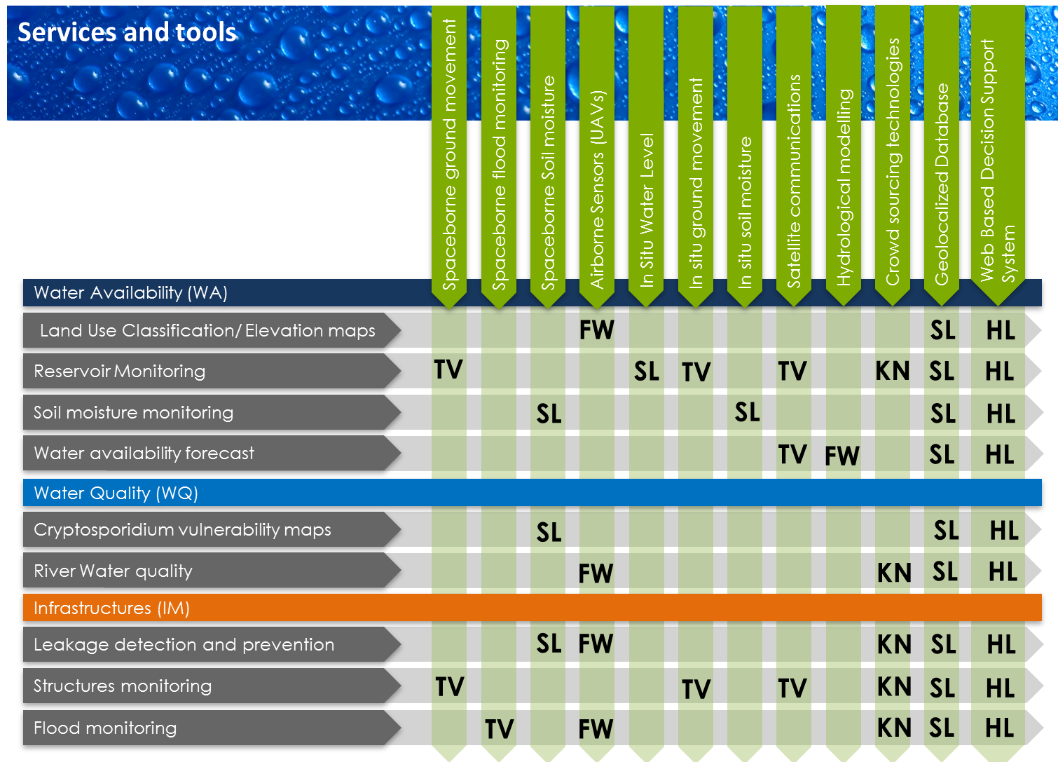
Services and tools that will be explored throughout the OWASIS-UK project. The acronyms are «FW» for FutureWater, “TV” for Telespazio VEGA UK Ltd., “SL” for Starlab Limited UK, “KN” for Knowledge NOW, and “HL” for Hydrologic.
EO is an important enabling technology for the better management and accounting of UK’s water resources. The main objective of this study is to explore the potential to combine optical and gravity data from EOS with meteorological data, together with innovative in situ sensors, hydrological modelling and crowd sourcing technologies, and the advanced visualization of the information through situation awareness platforms and decision support tools, in order to better monitor, forecast and control the quality and availability of water. Not only the resulting services will be useful for the water industry in UK, but also they are expected to be cost-effective, sustainable, and exportable to broader user groups such as farming industry, environment board, as well as other countries where water issues can be tackled with the same tools.
FutureWater is mainly involved in the following tools and services to be explored during this project:
Airborne Sensors (UAVs):
Land use classification/elevation maps
River water quality
Leakage detection and prevention
Flood monitoring
Hydrological modelling:
Water availability forecast
Example of ultra-high resolution information based on Flying Sensors (floodplain near Arnhem, NL, 4-Jun-2013).