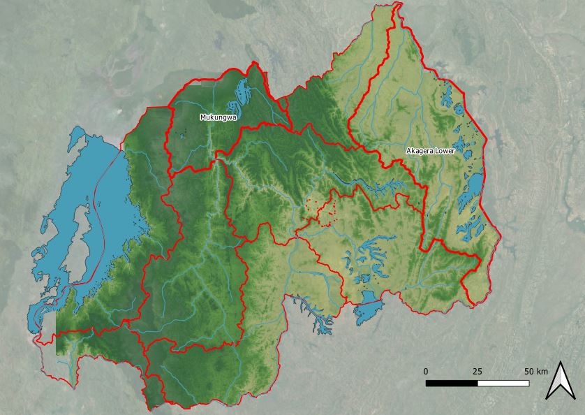
Agriculture is a key sector of the Rwandan economy; it contributes approximately 33% to the gross domestic product and employs more than 70% of the entire labour force. Although some farmers are already using water-efficient irrigation infrastructure, too much of the available water is still lost due to unsustainable use of existing irrigation systems, and/or maximum crop yields are not achieved due to under-irrigation.

Hence, small to medium-sized food producers in Rwanda do not have sufficient access to information regarding optimal irrigation practices. To close this information gap, FutureWater has devised an innovation that can calculate a location-specific irrigation advice based on Virtual Weather Stations, expressed in an irrigation duration (“SOSIA”). The use of the outdated CROPWAT 8.0 method, and the lack of good coverage of real-time weather stations in Rwanda, means that current advice falls short. In addition, existing advisory services are often too expensive for the scale on which small to medium-sized farmers produce. There is a potential to increase the productivity of the irrigation water by up to 25%. Initially, the innovation will be disseminated via the Holland Greentech network, with a pilot in Rwanda consisting of 40 customers. Aside from further refining the SOSIA tool, upscaling strategies will be explored in this second phase to identify other intermediaries that could benefit from the SOSIA service so to realize its optimal impact.

FutureWater has found with Holland Greentech an ideal partner to roll-out this innovation due to their presence in and outside of Rwanda, where they provide irrigation kits and advice. This offers the opportunity to quickly scale-up the proposed innovation. With their expertise in agro-hydrological modeling and the African agricultural sector, FutureWater and Holland Greentech respectively have acquired ample experience to make this innovation project and its knowledge development to a success.

The tools can be accessed through online URLs for the Virtual Weather Stations and for the Irrigation Advisory Tool.

El proyecto de consultoría “Planificación y gestión estratégica integrada de los recursos hídricos para Ruanda” evaluará la disponibilidad de los recursos hídricos del país para el horizonte 2050 y su vulnerabilidad frente al cambio climático. En base a las previsiones de disponibilidad y riesgo, se realizará una priorización de las posibles opciones de inversión en infraestructura gris y verde que podrían ser integrados en la planificación hídrica nacional para alcanzara los objetivos de seguridad hídrica y de desarrollo sostenible (ODS 6).

La evaluación de recursos hídricos en un contexto de cambio climático se apoyará en herramientas de modelización hidrológica y asignación de recursos entre diferentes usos (modelo WEAP), y de contabilidad del agua a nivel de subcuenca. Paralelamente a la modelización se realizarán trabajos de campo orientados a la evaluación de los recursos hídricos subterráneos. Los mecanismos de asignación de recursos se cuantificarán bajo diferentes escenarios de uso incorporando las visiones y demandas de las partes interesadas.

Tras la evaluación de recursos y demandas-asignación, se cuantificará el potencial existente para incrementar la capacidad de almacenamiento y regulación de agua mediante la inclusión de infraestructura gris (embalses) y verde (Soluciones basadas en la Naturaleza). La evaluación del potencial y priorización de las soluciones planteadas se apoyará en visitas de campo y un análisis de viabilidad y DAFO las opciones candidatas. Para las opciones finalmente seleccionadas se desarrollarán fichas descriptivas de carácter conceptual para su integración en los instrumentos de planificación.

Por último, y en base a los resultados obtenidos en las tareas interiores, el trabajo de consultoría apoyará la revisión de la política nacional de gestión y planificación de recursos hídricos mediante la definición de nuevas declaraciones y políticas que ayuden a alcanzar los objetivos NST1 y Visión 2050.

Several catchment plans have been already developed through the Dutch-funded Water for Growth programme. FutureWater played a paramount role in this programme by developing the water allocation models (WEAP) at national level and for several priority catchments. Moreover, FutureWater provided capacity building to local experts and staff on using and further developing and fine-tuning those WEAP models.

The current project aims at developing two catchment plans, for:

  1. Mukungwa catchment
  2. Akagera Lower catchment

These catchments were included in a previous national-level water resources allocation study performed by FutureWater. Four catchments were selected from this national level assessment to make catchment-level WEAP models to inform the catchment plans. A next step for the Rwanda Water Resources Board (RWB), is to prepare catchment plans for the above two catchments, for which this project will be instrumental.

For the two catchments, this study aims at (1) providing detailed information on available and renewable water resources, both surface and groundwater, and their spatial and temporal variations; and (2) to map and quantify water uses and water demands, to develop water allocation models that can be used as tools to manage operationally and plan the catchments in a sustainable way. The scenarios (options) assessed can also be essential input into the catchment management plan. This study will produce water allocation models based on current and potential uses in a time-horizon of 30 years.

The project is carried out in collaboration with a team of local experts and one of our partners Dr. Kaan Tuncok as a team leader.

Mukungwa and Akagera Lower catchments

The training aimed at building and enhancing capabilities of the participants in environmental and hydrological monitoring and modeling and was funded by the Orange Knowledge Program of Nuffic. It gave the participants valuable and necessary knowledge on IWRM and it provided the participants with relevant hands-on experience and cutting-edge knowledge on innovative solutions in water allocation modeling and earth observation technologies.

Due to the ongoing COVID-19 situation, the training was held online using our eLearning platform FutureWater Moodle School. The beauty of this platform is that all online sessions can be recorded and they are still available for the participants to have another look at it. All material (exercises, manuals etc.) developed during the course is also still available on our FutureWater Moodle School. The Rwanda Water Resources Board is recruiting new staff in the future and this new staff will also have access to all material.

Topics covered in the training are:

WEAP:

  • Build a WEAP model from scratch
  • Work with WEAP’ Basic Tools
  • Create and run Scenarios in WEAP
  • Extract water balances from WEAP
  • Generate a hydrological model using WEAP’ Automatic Catchment Delineation Tool

Google Earth Engine:

  • First glance at JavaScript Syntax
  • Explore and visualize Landsat 8 Imagery
  • Create charts with Monthly NDVI Values
  • Use WaPOR for Water Productivity calculations
  • Work with CHIRPS Rainfall data
  • Evaluate the water balance of a catchment


At the outlet of the 60 km-long Muhazi Lake there is currently an earth fill dyke which is prone to overtopping or even complete collapse during the wet season. The dyke’s instability causes a potential hazard to inhabitants of the downstream Nyabugogo area, a commercial hub in Kigali town, which threatens lives and properties.

The project consisted of a feasibility and a design phase. For the project, a large number of field- and desktop-tasks were performed. Field-activities included a topographical survey of the project immediate area for design purposes, a detailed mapping of areas around the lake shore sensitive to changes in water level, and a Geotechnical investigation programme due to the complexities related to the peat-soils.

FutureWater conducted a full hydrological assessment of the Lake Muhazi catchment, including the study of flood flows to provide design values, considering climate change, and routing of the lake. Besides, a detailed water resources assessment was performed using WEAP and a study on the operational rule curves, future demands, among others.

Muhazi Lake and dam.

The outputs of this analysis fed directly into the design of the Dyke (serving as a dam): the dimensions and outlet structures, performed by the lead partner (Z&A). Besides the project included an Environmental and Social Impact Assessment

Stakeholders were involved actively during all phases of work and several training and capacity building activities were organized.

En su esfuerzo por introducir el marco de Gestión Integrada del Territorio y el Agua, el Gobierno de Ruanda a través de la iniciativa “Agua para el crecimiento de Ruanda” (Water for Growth Rwuanda), empezó a desarrollar planes de gestión de cuenca del país. El programa “Agua para el crecimiento de Ruanda” es una plataforma para promover el marco de Gestión Integrada de Recursos Hídricos (GIRH, o IWRM en sus siglas en inglés) en Rwanda y que cuenta con el apoyo de la Embajada del Reino de los Países Bajos. El objetivo general del programa es «gestionar eficazmente los recursos hídricos para contribuir a un desarrollo socioeconómico sostenible y la mejora equitativa de los medios de vida». El programa centra sus esfuerzos en promover:
:

  • La investigación y la capacitación en Gestión Integrada de Recursos Hídricos (GIRH)
  • Implementación de los principios de la GIRH in cuatro cuencas piloto
  • Desarrollo de planes sostenibles de gestión integrada del agua
  • Creación de un Fondo de Inversión en GIRH abierto a otros donantes

FutureWater y eLEAF proporcionaron su experiencia y conocimiento para llevar a cabo dicho proyecto. Se desarrollo un enfoque centrado en el cliente, y se seleccionaron cuidadosamente un conjunto de herramientas caracterizadas por su facilidad de uso, su flexibilidad hacia la disponibilidad de datos, y un fuerte enfoque hacia la simulación de escenarios futuros.

Muchos proyectos de GIRH fracasan debido a la ausencia de un enfoque o visión de futuro bien definido. Al combinar conjuntos de datos locales y datos obtenidos con teledetección en modelos hidrológicos, se puede obtener información sobre la transpiración de los cultivos, los flujos de agua subterránea, la recarga y la escorrentía. WEAP incorpora estos componentes del balance a través de una plataforma práctica específicamente diseñada para la evaluación y planificación de recursos hídricos y el análisis de planes y políticas hidrológicas. La combinación de estas componentes a través una plataforma de modelización como WEAP proporciona una base sólida para hacer una evaluación más certera de la disponibilidad y distribución equitativa del agua.

Demonstration catchments of Water for Growth Rwanda
Cuencas piloto seleccionadas para la modelización con WEAP.

El proyecto se estructura en tres fases:

Fase I. El objetivo es la generación de mapas de evapotranspiración (ET), producción de biomasa (BP) y de productividad del agua de biomasa (BWP) para todo el país de Ruanda. Estos mapas son capas de entrada para los modelos de cuenca desarrollados en WEAP para los cuatro pilotos seleccionados (modelos WEAP-C).

Fase II. Tiene como objetivo utilizar WEAP para desarrollar un modelo de asignación óptima de agua a escala nacional (modelo WEAP-R). El modelo nacional se usa para evaluar los patrones de asignación para dos horizontes de proyección de 10 años de longitud (centrados en 2020 y 2050). Los modelos desarrollados para cada escenario de simulación se alimentan con datos locales, globales y de teledetección, y se configuraron para un paso de ejecución mensual  y usando el periodo de calibración-validación 2006-2015.

Fase III. Se proporciona capacitación técnica en el uso y manejo de los cuatro modelos WEAP-C y el modelo WEAP-R, haciendo especial énfasis en la adopción de un enfoque participativo e interactivo que promueva una mejor comprensión de los equilibrios del agua y los problemas de asignación.

The Nile Basin Decision Support System (NBI-DSS) will provide the necessary knowledge base and analytical tools to support the planning of cooperative joint projects and the management of the shared Nile Basin water resources on an equitable, efficient and sustainable manner. FutureWater was asked to support this NBI-DSS and to undertake preliminary data collection and compilation.

Details

The developed data base has two main components: spatial data and point data. Regarding the spatial data the following data have been made available

  • Land cover
  • Soils
  • Vegetation Indices
  • Precipitation FEWS

These data are available over the entire Nile Basin and include a extensive set of attributes. Data have been quality controlled and is ready to apply in the DSS and can be used for various types of hydrological models.

The point data includes over 20 million records from various sources included global and local data sets. Data are stored in PostGreSQL. The data can be considered as the most complete hydro-meteorological dataset available for the Nile so far.

The countries included in the Nile Equatorial Lake sub-basins face an ever increasing pressure on land and water resources, together with rapid population growth. As a result, food production is one of the main concerns and priorities of policymakers in the area. Irrigation and improved water resources management have the potential to boost agricultural productivity in the area, currently almost entirely rainfed. Irrigated crop yields are much higher than rainfed yields, which means that there is a high potential to increase food production in the area.

FutureWater, in collaboration with WaterWatch, will assess the irrigation potential of seven Nile countries in order to fill gaps in the NBI and member country information based on agricultural use. This study consists of several consecutive steps, in which hydrological modelling, the use of remote sensed data, ArcGIS analyses, consultation workshops and meetings form the core of the project.

The specific objectives of this project are:

  • Determine the irrigation potential of the proposed countries considering the physical resources of ‘soil’ and ‘water’, combined with the irrigation water requirements as determined by the cropping patterns and climate
  • Provide a preliminary assessment of probable environmental and socio-economic constraints to be considered to ensure sustainable use of physical resources within the Nile basin
  • Indicate the required resources for the preparation and investment phase

NEL countries

Maps

The assessment of the Irrigation Potential study resulted in a irrigation suitability map. This map can be downloaded as jpeg or as GeoTIFF. Click on the links below to download the suitable format: