Estamos mejorando la herramienta WE-HARP: Evaluación Hidrológica basada en WEAP para Permisos de Recursos Hídricos, que conecta la base de datos de permisos con una interfaz para la evaluación de nuevas licencias de aguas superficiales.
To ensure effective implementation, FutureWater will maintain continuous engagement with ARA-Sul, providing technical support and collecting feedback through online sessions. This collaboration will help address challenges in system integration, troubleshoot issues, and refine functionalities. A significant component of this phase is the development of a comprehensive user manual and training materials, including PowerPoint slide decks, to guide ARA-Sul staff in effectively utilizing the tool for water licensing assessments. By embedding the tool within ARA-Sul’s operations, FutureWater aims to enhance decision-making capabilities and streamline the management of water resources in the region.
La Plataforma Técnica Interregional sobre Escasez de Agua (iRTP-WS), liderada por la Organización de las Naciones Unidas para la Alimentación y la Agricultura (FAO), busca cerrar brechas entre la práctica y la innovación para impulsar un cambio transformador en la gestión del agua, la tierra y la agricultura, especialmente ante el cambio climático. Su enfoque está en fortalecer la preparación de los sistemas para afrontar desafíos relacionados con el agua, la alimentación y el clima mediante una mejor gobernanza, desarrollo de capacidades y aprendizaje en línea.
Para 2024-2025, el plan de trabajo se centra en «Soluciones Integradas para el Agua: Navegando el Cambio Climático y la Dinámica del Nexo Agua-Energía-Alimentos-Ecosistemas (WEFE)». La Oficina Regional de la FAO para Asia y el Pacífico lidera la Prioridad Estratégica 1: Pensamiento Nexus, promoviendo una toma de decisiones inclusiva y multisectorial para optimizar el uso de los recursos e implementar soluciones sostenibles basadas en WEFE.
Para respaldar la toma de decisiones basada en el enfoque nexus, la FAO, en colaboración con FutureWater, está desarrollando una herramienta que aprovecha los datos de Water Accounting para proporcionar información accesible sobre la dinámica de WEFE. Esta herramienta integrará WEAP y su API en un entorno de Excel, facilitando el análisis de escenarios tanto para proyecciones como para intervenciones. Al combinar las fortalezas de ambas plataformas, ofrecerá un enfoque intuitivo, estandarizado y colaborativo de Water Accounting, contribuyendo a un marco de toma de decisiones más armonizado.
A consortium of international development finance institutions led by World bank and including Asian Development Bank (ADB) have signaled their intention to support the financing of the Project. ADB is committed under Strategy 2030 operating priority 3 to support its Developing Member Countries to ensure a comprehensive approach to build climate and disaster resilience. The climate risk management approach of the ADB aims to reduce risks resulting from climate change to investment projects by identifying climate change risks to project performance in the early stages of project development, and which will support decision-making to incorporate the most appropriate adaptation measures in the design.
An initial climate risk assessment has been completed for the Rogun HPP project including assessments of natural hazards, hydrology, sedimentation, and the impact of climate change projections on project performance, however downstream resource implications have not been assessed. In this project FutureWater addresses wider system-level adaptation needs across the Amu Darya basin due to increased water use demand during the Rogun HPP reservoir filling period, climate-driven change to water supply and demand, and identification of potential supply-demand gaps. A combination of hydrological and water allocation modeling will form an evidence-base to inform recommended adaptive measures for the design and operation of Rogun HPP and for wider water-use sectors where required.
FutureWater undertakes analysis to understand projected climate change driven changes in water supply in Rogun HPP upstream areas, and water demands in downstream areas and the wider Amu Darya basin, with a focus on identifying the potential for a supply-demand gap throughout the Rogun HPP reservoir filling period to 2040. Where a risk of a supply-demand gap is identified FutureWater provides recommended measures that can increase water efficiency in the competing demand use sectors with the overall aim of meeting demand across the different scenarios and in compliance with cross-boundary resource sharing agreements.
Specifically, FutureWater addresses following topics:
Model projected water supply and demand in the Amu Darya river basin by utilizing a WEAP model developed for water supply, demand and allocation analysis, and accounting for climate change, Rogun HPP reservoir filling schedule, changing hydrology patterns and changes to downstream water demand from irrigation and other relevant end-use demands, where relevant.
Analyze the potential for water resource supply-demand gap to 2040 for a range of climate scenarios that capture potential future pathways aligned to government plans and policies and climate change, where relevant.
Recommend required water efficiency measures, where a risk of a supply-demand gap is identified under the the limits set by the cross-border water resource sharing agreement, so as to mitgate the risk with high-level cost estimate where capital investment is required.
The Food and Agriculture Organization (FAO) launched the Asia-Pacific Water Scarcity Program (WSP) to help countries across the region address the increasing challenges of water scarcity. The program aims to promote sustainable water use and support economic productivity despite growing water constraints.
Mongolia’s inclusion in the WSP presents a valuable opportunity to strengthen its water management capabilities. By applying proven methodologies and resources, the program will enhance the capacity of Mongolia’s Water Resource Ministries and River Basin Organizations (RBOs) to tackle the country’s unique water challenges effectively.
To demonstrate the effectiveness of Water Accounting for improved water management under a changing climate, FutureWater, with FAO’s support, is conducting a Water Accounting assessment for Mongolia’s two key river basins—the Tuul and Orkhon. Using cutting-edge techniques and tools, this initiative will provide critical insights to support sustainable water allocation and long-term resilience.
The GEF / UNDP / ASEAN Project on Reducing Pollution and Preserving Environmental Flows in the East Asian Seas through the Implementation of Integrated River Basin Management (IRBM) in the ASEAN Countries is a 5-year project (2023-2027) with the goal of establishing functional IRBM mechanisms in seven priority river basins / sub-basins / watersheds in six ASEAN Member States, to reduce pollution, sustain freshwater environmental flows and adapt to climate change vulnerabilities. The Project is designed to improve governance and management arrangements in IRBM and accelerate the required changes in the six AMS in support of national priorities, objectives and commitments to global sustainable development targets using the Source to Sea (S2S) framework. The PEMSEA Resource Facility (PRF), which serves as the Project Implementing Partner, hosts the Regional Project Management Unit (RPMU). It works in collaboration with National and Local Government Partners and River Basin Organizations.
Component 1 of the Project focuses on the conduct of a baseline assessment of the S2S management continuum with a targeted outcome of improving understanding of governance, socioeconomic, ecological conditions, gaps and needs of priority river basins / sub-basins and coastal areas. This will be achieved through the establishment of the State of River Basin (SORB) reporting system to consolidate information coming from administrative, social, economic and environmental sectors. As an input to the SORB baseline reporting, it is required to complete a comprehensive assessment of competing uses and users of water as a consequence of existing and future water uses and their implications on the water / energy / food / ecosystem (WEFE) security nexus in the priority river basins.
FutureWater is providing this assessment of the WEFE security nexus through review of existing knowledge and literature, stakeholder consultations, as well as tailoring and applying its REWEFe toolkit for nexus analysis to seven river basins in six countries of Southeast Asia: Cambodia, Indonesia, Lao PDR, Malaysia, Philippines and Viet Nam.
The UNDP is implementing the project “Conservation and sustainable management of lakes, wetlands, and riparian corridors as pillars of a resilient and land degradation-neutral Aral basin landscape supporting sustainable livelihoods” to enhance the resilience of the ecosystems and livelihoods in Lower Amudarya and Aral Sea Basin (LADAB) through land degradation neutrality (LDN) compatible integrated land-water management.
This assignment contributes to water allocation analysis and the development of water supply scenarios for irrigated agriculture and biodiversity conservation reports. The services consist in:
Consulting with project experts, government agencies, local communities, and other relevant stakeholders
Develop a hydro-economic water allocation model for the lower Amu Darya basin using WEAP
Explore different scenarios for irrigated agriculture and biodiversity conservation, considering climate change, to strike a balance between sustainable agricultural practices and conservation of biodiversity and ecosystems and (iv) build capacity and support project experts and relevant stakeholders on water allocation analysis and modelling.
Stakeholders consultation in Nukus, Uzbekistan
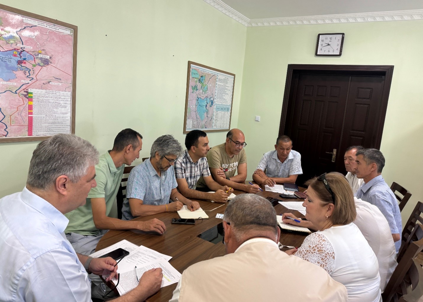
The WEAP model simulates water availability, supply, and demand on a small scale for over 40 irrigation, domestic, and industrial sites, running on a daily timestep to include detailed reservoir operations and water use abstractions. The updated WEAP model was co-designed together with ARA-Sul, the regional water authorities of southern Mozambique. Monthly meetings were held to support information sharing and co-ownership throughout the project.
The model will aid ARA-Sul in water accounting and the licensing of water users served by the Pequenos Libombos Reservoir. The Pequenos Libombos Reservoir, with a storage capacity of 350 MCM, is the main water supplier to the Maputo Metropolitan Area inhabited by over 3 million people. In June 2024 sessions were held in The Netherlands were ARA-Sul was trained in the usage of the model.
The cover picture was taken by David Mucambe (ARA-Sul).
La mayoría de las investigaciones recientes se han centrado en la identificación de episodios históricos basados en paleoregistros y la comprensión de sus causas climáticas, o en el estudio de megasequías “modernas” y sus impactos, generalmente en cuencas bajas y llanuras. Sin embargo, las cuencas de montaña han sido poco estudiadas y poco se sabe sobre el impacto de las megasequías en el estado y dinámica de la criosfera o torres de agua de montaña. Las cuencas vertientes dependientes de sistemas de alta montaña disponen de una capacidad para amortiguar la falta de precipitaciones y exceso de evapotranspiración que depende de las reservas de agua proporcionadas por la criosfera (nieve, glaciares y permafrost). Se presume, que la capacidad de amortiguación es limitada hasta alcanzar un punto de inflexión donde los impactos de la falta de agua y temperaturas extremas pueden verse amplificados y poner en peligro el funcionamiento del ecosistema hídrico.
MegaWat tiene un doble objetivo: 1) abordar las lagunas de conocimiento entorno a las causas hidroclimáticas de las sequías extremas y su impacto en el balance del agua de las torres de agua de montaña de Europa, haciendo especial énfasis en la concurrencia de eventos compuestos y los efectos en cascada y multiescala, y 2) desarrollar y proponer nuevas estrategias de adaptación para hacer frente a la duración, extensión e intensidad de futuras megasequías y sus impactos ambientales y socioeconómicos.
Para su implementación, MegaWat se centra en los sistemas de alta montaña de Europa y sus cuencas vertientes. MegaWat ambiciona el desarrollo de tres productos:
Producto 1. Marco metodológico para la identificación y caracterización de megasequías históricas durante el periodo instrumental, y la evaluación del papel que juega la criosfera en la amortiguación de los impactos del cambio climático y el desarrollo territorial en las cuencas vertientes. El producto 1 descansa en la combinación de herramientas de regionalización climática, modelización del balance de energía en superficie, simulación hidrológica, y códigos de evaluación y asignación optimización de recursos hídricos.
Producto 2. Base de datos climática regionalizada de alta resolución y de acceso libre. (ver figura)
Producto 3. Listado de estrategias de adaptación para la prevención y amortiguación de impactos, y el aumento de la seguridad hídrica y resiliencia de cuencas de alta montaña. Estos escenarios serán consensuados con agentes locales y partes interesadas, y su efectividad se evaluarán bajo escenarios extremos, no antes descritos pero plausibles, en tres cuencas piloto de alta montaña previamente seleccionadas por su representatividad, importancia estratégica y vulnerabilidad a las sequías.
Representación esquemática de una cuenca de alta montaña, incluyendo los principales componentes, procesos e impactos relacionados con sequías.
En MegaWater, FutureWater coordina el paquete de trabajo para el desarrollo e implementación de herramientas de soporte a la decisión y adaptación a megasequías, incluyendo la organización de actividades con actores locales y partes interesadas para la priorización de intervenciones y puesta en común de resultados. El paquete de trabajo se organiza a través de dos actividades específicas: a) el desarrollo de un prototipo metodológico para cuantificación de impactos en cuencas vertientes y la identificación de puntos de inflexión para la seguridad hídrica, y b) el uso e integración de indicadores de estado de la criosfera en un sistema de alerta temprana, InfoSequia. como potenciales predictores de impacto y riesgo hídrico. (ver figura)
Esquema del Sistema de Alerta Temprana InfoSequia desarrollado por FutureWater y adaptado para la detección de riesgos hídricos en cuencas de alta montaña. Más información sobre InfoSequia.
La ficha descriptiva de MegaWat se puede descargar aquí.
Agradecimientos
Este proyecto ha recibido financiación del programa Water4All con cofinanciación de CDTI y del Programa Marco de Investigación e Innovación Horizonte Europa de la Unión Europea.
The aim is to develop a business case for a Watershed Investment Program for Addis Ababa. It includes stakeholder and governance analysis, scientific modeling, return on investment (ROI) analysis, and an implementation plan. Hydrological models are employed to assess the potential of Nature-based Solutions to mitigate the negative trends in the watershed, and improve water supply reliability, water quality, sedimentation and agricultural productivity. The study should raise awareness for all key stakeholders and potential investors. The study is performed under the Nature for Water Facility launched by The Nature Conservancy.
Southern Spain is a highly productive agricultural region, but with huge challenges around water scarcity and environmental sustainability. There is a demand in the agricultural sector to work towards water stewardship in Spain. The Alliance for Water Stewardship has developed a Standard which helps retailers and their suppliers to cause change at scale. This approach recognizes that there are common challenges that could be more easily overcome through a collective, place-based approach.
In the Doñana region, berry farms and groundwater usage are causing a conflict with the unique ecosystems in the National Park. A catchment assessment and active stakeholder engagement is needed as a first step in this region to work towards water stewardship. The catchment assessment will provide information on the catchment context, in line with the requirements of the Standard. The purpose of the assessment is to reduce the burden on agricultural sites by providing them with a common set of information which they and others can use to inform responses to their shared water challenges.