El proyecto BUCRA (Construyendo Unidad para una Agricultura Resiliente al Clima) se centra en mejorar la resiliencia agrícola en Qahbunah, una comunidad agrícola en el delta del Nilo en Egipto. Frente a desafíos como la escasez de agua, el cambio climático y la fragmentación de la tierra, los agricultores locales requieren enfoques innovadores para sostener sus medios de vida.

En el corazón de BUCRA se encuentran dos herramientas de vanguardia desarrolladas por FutureWater: Croptimal y SOSIA, que combinan tecnología avanzada con conocimientos locales para transformar las prácticas agrícolas tradicionales.

Croptimal es una herramienta de análisis de idoneidad climática que aprovecha proyecciones climáticas, datos geoespaciales y conocimientos agrícolas para evaluar la idoneidad de diversos cultivos bajo escenarios climáticos actuales y futuros. Al identificar áreas y cultivos que son más resilientes a factores climáticos adversos como el calor, la salinidad y la escasez de agua, Croptimal empodera a los agricultores con recomendaciones basadas en datos para optimizar la selección de cultivos y estrategias de siembra. Esta herramienta proporciona mapas altamente detallados y consejos prácticos, lo que permite a los agricultores adaptar sus prácticas a los desafíos del cambio climático mientras aumentan su productividad.

SOSIA (Asesoría de Riego de Código Abierto Basada en Satélites) es una herramienta de gestión del riego diseñada para mejorar la eficiencia en el uso del agua. Utiliza datos satelitales de código abierto, información meteorológica en tiempo real y condiciones locales del suelo para proporcionar recomendaciones diarias de riego precisas. Los agricultores reciben indicaciones a través de WhatsApp sobre cuánto tiempo regar sus cultivos cada día, lo que hace que el servicio sea accesible y rentable. Este enfoque innovador no solo reduce el consumo de agua, sino que también mejora los rendimientos de los cultivos y la eficiencia energética, abordando las crecientes presiones sobre los recursos hídricos en el delta del Nilo.

Además de estas herramientas, BUCRA incluye parcelas de demostración que exhiben técnicas inteligentes frente al clima, como el riego eficiente, la gestión del suelo y la rotación de cultivos. Los agricultores también participarán en un programa de aprendizaje combinado que integra capacitación práctica en campo con aplicaciones digitales fáciles de usar para mejorar sus habilidades técnicas y conocimientos.

BUCRA pone un fuerte énfasis en empoderar a la juventud y a las mujeres en la agricultura, fortalecer los vínculos con el mercado y promover prácticas sostenibles de uso del suelo. Al alinear la experiencia neerlandesa con las necesidades locales, el proyecto tiene como objetivo aumentar la productividad, estabilizar los ingresos y construir un futuro agrícola sostenible en Qahbunah.

La visión a largo plazo es inspirar una adopción más amplia de estas herramientas y prácticas, garantizando la seguridad alimentaria e hídrica en la región mientras se abordan los desafíos que plantea el cambio climático.

The UNDP is implementing the project “Conservation and sustainable management of lakes, wetlands, and riparian corridors as pillars of a resilient and land degradation-neutral Aral basin landscape supporting sustainable livelihoods” to enhance the resilience of the ecosystems and livelihoods in Lower Amudarya and Aral Sea Basin (LADAB) through land degradation neutrality (LDN) compatible integrated land-water management.

This assignment contributes to water allocation analysis and the development of water supply scenarios for irrigated agriculture and biodiversity conservation reports. The services consist in:

  1. Consulting with project experts, government agencies, local communities, and other relevant stakeholders
  2. Develop a hydro-economic water allocation model for the lower Amu Darya basin using WEAP
  3. Explore different scenarios for irrigated agriculture and biodiversity conservation, considering climate change, to strike a balance between sustainable agricultural practices and conservation of biodiversity and ecosystems and (iv) build capacity and support project experts and relevant stakeholders on water allocation analysis and modelling.
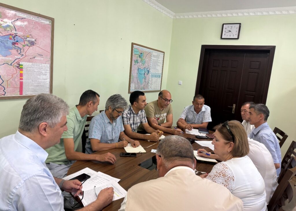
Stakeholders consultation in Nukus, Uzbekistan

Analysis of the historical climate data and future model projections indicates significant shifts in rainfall patterns. These shifts could influence water availability within the upstream river basins, which are vital for irrigation practices and ecological balance. Furthermore, the study explores variations in temperature -including average, minimum, and maximum values- and evaluates their potential consequences on water demand due to increased evaporation rates and altered crop water needs.

Additionally, this scoping research touches upon the effects of these climatic factors on olive crop phenology and productivity. The study also considers the likelihood of extreme weather events, such as heatwaves and droughts, and their potential to disrupt traditional farming cycles and water resource management strategies.

The outcomes of this analysis are aimed at providing an olive producing firm with insights and strategies to mitigate the adverse effects of climate change on olive production in these targeted regions of Andalucia. By foreseeing potential challenges and preparing for them, a decision can be made on whether to invest or not in order to maintain a leading olive producer on the global stage.

Para lograr los objetivos, el proyecto cuenta con un componente técnico y un componente de participación de las partes interesadas. En el aspecto técnico, se actualizarán y validarán modelos hidrológicos. Los escenarios de cambio climático se utilizarán como insumos para probar estrategias de adaptación dentro de la cuenca del Limpopo. Las estrategias de adaptación incluirán infraestructura gris tradicional y, adicionalmente, soluciones basadas en la naturaleza. El análisis de beneficios de las medidas de adaptación abarcará beneficios socioeconómicos a nivel macro y micro.

Los resultados de este estudio se utilizarán posteriormente para informar el desarrollo de un Análisis Diagnóstico Transfronterizo (ADT) de primera generación para la cuenca del río Limpopo (LRB). A través de este proceso, los países de la cuenca acordarán un conjunto de prioridades de desarrollo transfronterizas para la cuenca, lo que guiará tanto las inversiones transfronterizas como nacionales en el futuro, a través de un Plan de Acción Estratégico (PAE) y Planes de Acción Nacionales (PAN).

This consultancy project is framed by the AQUIFER project, “Innovative instruments for the integrated management of groundwater in a context of increasing scarcity of water resources” (Interreg-SUDOE V programme) which aims to capitalize, test, disseminate and transfer innovative practices for the preservation, monitoring and integrated management of aquifers.

FutureWater expertise was required for providing a novel and open-source hydrological modelling framework able to quantify spatial patterns of daily root percolation as a direct surrogate of groundwater recharge in the Campo de Cartagena Quaternary Aquifer (CC-QA). This aquifer is located at SE Spain and is one of the most important vectors of water drainage to the Mar Menor lagoon.

This task is addressed through the improvement and local calibration of the SPHY code for the Campo de Cartagena and the simulation of the water balance in the soil root zone from the 1950s until the end 2020. The SPHY-Campo de Cartagena includes a new routine able to compute irrigation inputs at the pixel level based on satellite data. Timeseries of monthly root percolation are taken as good surrogates of potential groundwater recharge and used as the main forcing input to an hydrogeological model of the Quaternary aquifer. The calibration process is performed through a sensititivity-intercomparison analysis in which model-derived outputs (irrigation and streamflow) during the calibration period are cross-checked against actual observations.

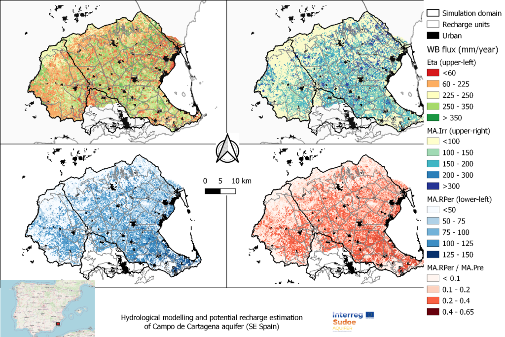
Spatial patterns of root percolation and the relative contribution of irrigation return flows to the total groundwater recharge were quantified (e.g. Figure 1) under historical and current conditions. Simulation results would show the lack of a significant temporal trend in the long-term recharge rates in the aquifer, most likely due to the the strong interannual variability observed in rainfall patterns, but also by the trade-offs resulting from the combination of climate, land use and irrigation-crop management drivers.

Figure 1. Mean Annual values of the main water balance components in Campo de Cartagena (2000-2020). RPer_ratio refers to the fraction between Root Percolation (MA.RPer) and Precipitation (MA.Pre)

The issue of water scarcity is intensifying across the Asia Pacific region, posing significant challenges for sustainable agricultural production and water resources management. The Water Scarcity Program (WSP), designed by FAO-RAP and partners, aims to bring agricultural water use within sustainable limits and prepare the sector for a productive future with less water. The program aims to assess the ongoing issue of water scarcity in the region, evaluate potential management options, and assist partner countries to implement adaptive management in the agriculture water sector using innovative tools and approaches.

As part of the WSP, FutureWater will design and deliver a two-phase water accounting training program in Indonesia, Vietnam and Thailand, respectively. The first phase of the training will primarily focus on introducing and better understanding the concept of water accounting, its components and approaches. Participants will also work with tools such as REWAS and Follow the Water (developed by FutureWater in collaboration with FAO) to conduct water accounting in agricultural systems at different scales. Through the use of these tools, participants will be able to estimate real water savings at system and basin scale, and also analyze the impact of different irrigation schemes on the overall water availability in the system. The second phase will consist of participants working on the selected basin in each country to develop a detailed water account. Given the data availability and accessibility issues in the region, the participants will learn how to access, process and analyse remotely sensed datasets using Google Earth Engine.

In addition to the trainings, FutureWater will also provide technical inputs for the regional WSP events on water scarcity and highlight the technical challenges of implemeting water accounting and allocation in south-east Asia for the WSP High Level Technical Meeting to be held in June 2024.

Looking at global climate change patterns and its increased pressure on natural resources, West African countries like Ghana will be hit very hard. In particular, agriculture, which is the largest water user in Ghana, will be affected by high temperatures and changes in the variability of rainfall. This variability in climate makes crop production and yield more uncertain, as well as farm income. The periods of droughts in Ghana are getting longer and there is increased pressure on water availability from the river basins due to climate change, putting many people and farmers in risk of having too little water. Therefore in this project, we will develop and pilot in the field an innovative tool that will significantly enhance water security in Ghana by reducing the quantity of water needed for irrigation per hectare (up to about 40% less of current water use).

To support the Ghanaian farmers in making the transition to a water secure future, they expressed a need for locally adapted, climate smart irrigation technologies and innovative advice to improve their irrigation practices. To develop such a smart irrigation service, FutureWater is working together with knowledge institute TU Delft, horticulture company Holland Greentech, and social enterprise TAHMO to develop this innovative tool and implement it in the field. This smart irrigation service should be able to translate various weather parameters and data (historical but also real-time data) into crop specific irrigation advice in volumes, but also in minutes for small-scale farmers. The unique and innovative part of this smart irrigation service, called SOSIA+ (Small-scale Open source, Satellite based Irrigation Advice), will be the algorithm to provide advice on how many minutes a farmer should irrigate a specific crop – based on the combination of the TAHMO local weather data and real-time data (normally not taken into account), that will be tailor-made for small scale farmers (normally these services are only for large scale farmers while the predominant type of farmers in Ghana are small scale) and is linked to the innovative drip irrigation systems that Holland Greentech Ghana already sells to farmers (so closely linked to an existing customer base of farmers and a product).

SOSIA+ will initially focus on the city of Kumasi and the Ashanti region, targeting more than 500 farmers and a growing population of more than 4 million people that needs to be fed and are affected by the changing weather patterns and increased water demand. In the long-term, the goal is to transform the horticulture sector in Ghana towards a smart and sustainable practice. By developing the Irrigation Advisory Tool, we can prevent over-irrigation to reduce water use and hence work towards the desired situation of sustainable food production and water security. This project will focus on gathering better weather information, piloting an innovative irrigation tool that is linked to a drip irrigation system to reduce water losses and implement this in the field with lead farmers. This will change the current traditional practices of the farmers leading to less water and energy losses, hence increasing availability of water and the sustainability of food production in light of climate change.

Earlier this year FutureWater and Holland Greentech developed a very first draft of the irrigation advisory application ‘SOSIA’ for Rwanda, with promising results. As one of the main problems in many African countries is that there is no ground network of weather stations, making it very difficult to efficiently manage water resources or generate weather forecasts that are localised and essential for food production, the initial SOSIA project used satellite remote sensing data to overcome this problem. But given the rapidly changing weather patterns due to climate change, the collection of ground data is also essential. This is why TAHMO has been set-up to develop a dense network of weather stations all over Africa and using their data will be very valuable to use for the irrigation tool.

The video below gives a brief summary of the tool created in the previous SOSIA project.

Actualmente, los agricultores dependen de pronósticos meteorológicos y recomendaciones que son, o bien generales para una región de interés determinada, a menudo extensa, o altamente personalizadas a las necesidades de los agricultores (por ejemplo, al combinar variables atmosféricas a gran escala en parámetros sintéticos de interés). En ambos casos, dichos pronósticos y recomendaciones a menudo no se basan en observaciones recopiladas en o alrededor de las áreas cultivadas objetivo, o se limitan a observaciones tradicionales proporcionadas únicamente por estaciones meteorológicas, sin aprovechar la gama completa de mediciones y observaciones disponibles a través de activos espaciales europeos (por ejemplo, Galileo GNSS, Sentinel de Copernicus) y datos de radar basados en tierra.

Los objetivos de MAGDA van más allá del estado del arte, al aspirar al desarrollo de un sistema modular que los propietarios de grandes explotaciones agrícolas puedan implementar directamente en sus instalaciones, alimentando de forma continua observaciones a modelos meteorológicos e hidrológicos dedicados y personalizados, cuyos resultados se mostrarán a través de un panel de control y/o dentro de un Sistema de Gestión Agrícola.

FutureWater lidera el servicio de asesoramiento de riego de MAGDA, utilizando modelos hidrológicos a través de SPHY (Procesos Espaciales en Hidrología). El resultado esperado consiste en un servicio de riego operativo que brinde recomendaciones sobre cuándo y cuánto regar en determinados momentos durante la temporada de cultivo, utilizando como datos de entrada pronósticos meteorológicos mejorados.

Durante esta tarea, se configurará el modelo de balance hídrico SPHY para tres explotaciones agrícolas demostrativas seleccionadas en Rumanía, Francia e Italia. Finalmente, el asesoramiento de riego se validará utilizando indicadores de rendimiento (por ejemplo, productividad del agua, análisis de rendimiento de cultivos, eficiencia en el uso del agua) con datos de campo (por ejemplo, estaciones meteorológicas, sondas de humedad, mediciones de biomasa de cultivos).

Los recursos hídricos en todo el mundo están sometidos a una presión cada vez mayor. Entre otros factores, el cambio climático, el aumento de la demanda de alimentos y energía y la mejora de los niveles de vida han multiplicado por seis las extracciones mundiales de agua durante el último siglo, con importantes consecuencias para la calidad y disponibilidad del agua, la salud de los ecosistemas y la biodiversidad. como estabilidad social.

Al promover y vincular modelos de sistemas hídricos con modelos de sectores como la agricultura y la energía, la biodiversidad o el transporte de sedimentos, el Proyecto SOS-Agua pretende sentar las bases para un marco de evaluación holístico de los recursos hídricos en escalas espaciales. Basado en cinco estudios de caso de cuencas fluviales en Europa y Vietnam (la cuenca del río Júcar en España, la región del Alto Danubio, los deltas de los ríos Danubio y Rin, y la cuenca del río Mekong), un equipo interdisciplinario de investigadores de diez instituciones en ocho países Desarrollar un SOS multidimensional para el agua. El marco permitirá evaluar los ciclos de retroalimentación y las compensaciones entre las diferentes dimensiones del sistema hídrico y ayudará a abordar desafíos globales, regionales y locales urgentes.

Además de ir más allá del modelado de sistemas hídricos de última generación, el proyecto desarrollará un conjunto integral de indicadores para evaluar y monitorear el desempeño ambiental, social y económico de los sistemas hídricos. Los investigadores participantes colaborarán con autoridades regionales y locales, representantes de los usuarios del agua, organizaciones no gubernamentales y ciudadanos para cocrear escenarios futuros y vías de gestión del agua. Al racionalizar la planificación hídrica en diferentes niveles, se puede garantizar que la asignación del agua entre sociedades, economías y ecosistemas sea económicamente eficiente, socialmente justa y resiliente a las crisis.

En asociación con el líder del proyecto IIASA y socios como la Universidad de Utrecht y EAWAG, FutureWater es responsable de varias tareas bajo el paquete de trabajo que busca mejorar las tecnologías de observación de la Tierra existentes para monitorear el desempeño de los sistemas de agua. Se desarrollarán y probarán nuevas aplicaciones en el contexto de las cuencas del estudio de caso SOS-Agua de los ríos Mekong y Júcar.

Para más información, visita la web del proyecto.

Uzbekistan is highly sensitive to climate change which will cause changes in the water flows and distribution: water availability, use, reuse and return flows will be altered in many ways due to upstream changes in the high mountain regions, but also changes in water demand and use across the river basin. The resulting changes in intra-annual and seasonal variability will affect water security of Uzbekistan. Besides, climate change will increase extreme events which pose a risk to existing water resources infrastructure. An integrated climate adaptation approach is required to make the water resources system and the water users, including the environment, climate resilient.

This project will support the Ministry of Water Resources (MWR) of Uzbekistan in identifying key priorities for climate adaptation in the Amu Darya river basin and support the identification of investment areas within Amu Darya river basin. The work will be based on a basin-wide climate change risk assessment as well as on the government priorities with an explicit focus on reducing systemic vulnerability to climate change.

The project will undertake:

  • Climate change risk analysis and mapping on key water-related sectors, impacts on rural livelihoods, and critical water infrastructures.
  • Climate change adaptation strategic planning and identify barriers in scaling up adaptation measures at multiple scales with stakeholder consultation and capacity building approach.
  • Identification of priority measures and portfolios for integration into subproject development as well as for future adaptation investment in the Amu Darya river basin. The identification will cover shortlisting of potential investments, screening of economic feasibility, and potential funding opportunities.

FutureWater leads this assignment and develops the climate risk hotspot analysis, and coordinates the contribution of international and national experts, as well as the stakeholder consultation process.