Eswatini’s development is at risk by natural drought hazards. Persistent drought is exacerbating the country’s existing challenges of food security and the ability to attain sustainable development. Therefore, FutureWater, Hydrologic, and Emanti Management joined forces to bring together technologies and complementary expertise to implement the GLOW service which includes: short-term and seasonal forecasts of water availability and demand, an alerting service when forecasted water demand is higher than water availability, and water distribution advisories to reduce impact and maximise water security for all water users.

The GLOW service will be piloted in the Maputo River and Mbuluzi River Basins where three-quarters of the population of Eswatini lives, which includes the Hawane dam that supplies water to Mbabane (Capital City of Eswatini) and which is the major water supply source for Maputo, a Delta city (1 million inhabitants) which suffers from water shortages. The main beneficiaries of this project are the Joint River Basin Authority (JBRAS-PB) and the 5 River Basin authorities, AraSul (Mozambique) and the Department of Water and Sanitation (South Africa).

The innovation of GLOW is bringing together proven and award-winning technologies of advanced earth observation, open data, high-performance computing, data-driven modelling, data science, machine learning, operations research, and stakeholder interaction. These technologies require minimum ground truth information, which makes them very scalable and applicable in poorly monitored environments throughout the world. The coherent combination of the technologies into one decision support service ensures the optimum division of water, basically distributing every drop of water to meet the demands of all interests present in large river catchments.

Water and food security are at risk in many places in the world: now and most likely even more in the future, having large economic and humanitarian consequences. Risk managers and decision-makers, such as water management authorities and humanitarian-aid agencies/NGOs, can prevent harmful consequences more efficiently if information is available on-time on (1) the impact on the system, economy or society, and also (2) the probabilities for a failure in the system. EO information has proven to be extremely useful for (1). For looking into the future, considering the uncertainties, novel machine learning techniques are becoming available.

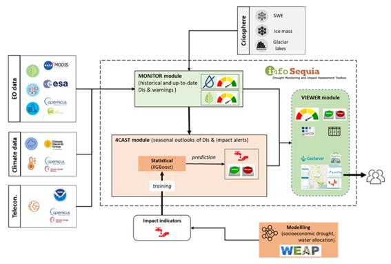
The proposed development is incorporated into an existing solution for providing Drought and Early Warning Systems (DEWS), called InfoSequia. InfoSequia is a modular and flexible toolbox for the operational assessment of drought patterns and drought severity. Currently, the InfoSequia toolbox provides a comprehensive picture of current drought status, based mainly on EO data, through its InfoSequia-MONITOR module. The proposed additional module, called InfoSequia-4CAST, is a major extension of current InfoSequia capabilities, responding to needs that have been assessed in several previous experiences.

InfoSequia-4CAST provides the user with timely, future outlooks of drought impacts on crop yield and water supply. These forecasts are provided on the seasonal scale, i.e. 3-6 months ahead. Seasonal outlooks are computed by a novel state-of-the-art Machine Learning technique. This technique has already been tested for applications related to crop production forecasting and agricultural drought risk financing. The FFTrees algorithm uses predictor datasets (in this case, a range of climate variability indices alongside other climatic and vegetative indices) to generate FFTs predicting a binary outcome – crop yields or water supply-demand balance above or below a given threshold (failure: yes/no).

The activity includes intensive collaboration with stakeholders in Spain, Colombia and Mozambique, in order to establish user requirements, inform system design, and achieve pilot implementation of the system in the second project year. Generic machine learning procedures for training the required FFTs will be developed, and configured for these pilot areas. An intuitive user interface is developed for disseminating the output information to the end users. In addition to development of the forecasting functionality, InfoSequia-MONITOR will be upgraded by integrating state-of-the art ESA satellite data and creating multi-sensor blended drought indices.

The Ministry of Water and Environment in Bolivia has asked the Dutch Government for support in relation to the drought issues they face. Last week, a team consisting of team leader Otto de Keizer (Deltares) and Johannes Hunink (FutureWater) left for Bolivia. As a result of El Niño, the country is struggling with a long and extreme drought period, which in November 2016 led to an acute water shortage in the capital La Paz and other areas of the country.

The Dutch government together with the Dutch water sector founded the Dutch Risk Reduction Team (DRR-Team). With the DRR instrument the Netherlands is able to cover the entire disaster management cycle from mitigation, preparedness and response to recovery.

To address the drought problem in Bolivia, the DRR-Team has been asked to provide recommendations on drought early warning and drought information systems, both on technical aspects as well as on institutional issues. The team has held talks with the Ministry of Environment and Water, the La Paz and Potosí drinking water companies, and the municipality of La Paz. In addition, they also consulted with SENAMHI: the National Hydrometeorological Institute. The DRR-Team drew up with a team of experts of the World Bank that supports Bolivia with several necessary investments to reduce vulnerability to drought.

Groundwater is one of the most important freshwater resources for mankind and for ecosystems. Assessing groundwater resources and developing sustainable water management plans based on this resource is a major field of activity for science, water authorities and consultancies worldwide. Due to its fundamental role in the Earth’s water and energy cycles, groundwater has been declared as an Essential Climate Variable (ECV) by GCOS, the Global Climate Observing System. The Copernicus Services, however, do not yet deliver data on this fundamental resource, nor is there any other data source worldwide that operationally provides information on changing groundwater resources in a consistent way, observation-based, and with global coverage. This gap will be closed by G3P, the Global Gravity-based Groundwater Product.

The G3P consortium combines key expertise from science and industry across Europe that optimally allows to (1) capitalize from the unique capability of GRACE and GRACE-FO satellite gravimetry as the only remote sensing technology to monitor subsurface mass variations and thus groundwater storage change for large areas, (2) incorporate and advance a wealth of products on storage compartments of the water cycle that are part of the Copernicus portfolio, and (3) disseminate unprecedented information on changing groundwater storage to the global and European user community, including European-scale use cases of political relevance as a demonstrator for industry potential in the water sector. In combination, the G3P development is a novel and cross-cutting extension of the Copernicus portfolio towards essential information on the changing state of water resources at the European and global scale. G3P is timely given the recent launch of GRACE-FO that opens up the chance for gravity-based time series with sufficient length to monitor climate-induced and human-induced processes over more than 20 years, and to boost European space technology on board these satellites.

In this project, FutureWater is in charge of a case which aims to prototype and calibrate a Groundwater Drought Index based on the G3P product, and to integrate it into InfoSequia, the FutureWater’s in-house Drought Early Warning System. The new InfoSequia component will be tested for inherent reliability and flexibility at the basin level in a total area of about 145 000 km2 in Southern Spain which largely relies on groundwater resources. This pilot region comprises three large basins (Segura, Guadalquivir and Guadiana) with many aquifers and groundwater bodies where very severe dynamics of overexploitation and mining have been identified and declared. Unsustainable groundwater development threats the water security in the region, but also the ecological status and preservation of unique and highly protected ecosystems in Europe (e.g., Doñana National Park, Daimiel National Park, Mar Menor coastal lagoon).

To visit the official G3P website, please click on this link: https://www.g3p.eu

Twiga’ is the Swahili word for ‘giraffe’, a keen observer of the African landscape. TWIGA aims to provide actionable geo-information on weather, water, and climate in Africa through innovative combinations of new in situ sensors and satellite-based geo-data. With the foreseen new services, TWIGA expects to reach twelve million people within the four years of the project, based on sustainable business models.

Africa needs reliable geo-information to develop its human and natural resources. Sixty percent of all uncultivated arable land lies in Africa. At the same time Africa is extremely vulnerable to climate change. Unfortunately, the in situ observation networks for weather, water, and climate have been declining since the 1970s. As a result, rainfall predictions in Africa for tomorrow have the same accuracy as predictions in Europe, ten days ahead. To realize the tremendous potential of Africa while safeguarding the population against impacts of climate change, Earth observation must be enhanced and actionable geoinformation services must be developed for policy makers, businesses, and citizens. New in situ observations need to be developed that leverage the satellite information provided through GEOSS and Copernicus (Open data/information systems).

TWIGA covers the complete value chain, from sensor observation, to GEOSS data and actionable geoinformation services for the African market. The logic followed throughout is that in situ observation, combined with satellite observations and mathematical models, will result in products consisting of maps and time series of basic variables, such as atmospheric water vapour, soil moisture, or crop stage. These products are either produced within TWIGA, or are already available with the GEOSS and Copernicus information systems. These products of basic variables are then combined and processed to derive actionable geo-information, such as flash flood warnings, sowing dates, or infra-structural maintenance scheduling.

The TWIGA consortium comprises seven research organisations, nine SMEs and two government organisations. In addition it uses a network of 500 ground weather stations in Africa, providing ready-to-use technical infrastructure.

FutureWater’s main role in TWIGA is centered around the use of flying sensors to map crop conditons, flood extent, and energy fluxes, complementing and improving data from in situ sensors and satellites. Furthermore, FutureWater is involved in innovative app development.

Breve descripción del Proyecto

Para apoyar una gestión sostenible y equitativa de los recursos hídricos cada vez bajo más presión, las autoridades competentes en materia de agua deben tener acceso a información actualizada sobre la disponibilidad y el uso de esos recursos. Sin embargo, esta información es a menudo escasa o, en el mejor de los casos, sólo está disponible como datos estáticos en  informes. Esto puede conducir a decisiones subóptimas, especialmente en situaciones críticas tales como sequías, que pueden conducir a disminuir la seguridad de la disponibilidad del recurso agua, frenar el desarrollo económico y social e incluso conducir a disputas y conflictos sobre la asignación de recursos.

HERMANA (Herramienta para el Manejo Integral del Agua), tiene como objetivo fomentar el desarrollo de un Sistema Integrado de Apoyo a la Toma de Decisiones en materia de recursos hídricos, que facilite la toma de decisiones diarias, tácticas y estratégicas relacionadas con los recursos hídricos en Colombia, específicamente en la Cuenca del Valle del Cauca. La herramienta HERMANA será un sistema integral capaz de proporcionar valiosos, pertinentes y fiables datos de aguas subterráneas y de aguas superficiales, así como información a los gestores de alto nivel y usuarios específicos, a un nivel apropiado de detalle y en el momento en que sea necesario. HERMANA, que se basa en el ejemplo de sistemas integrados de apoyo a la toma de decisiones en tiempo real recientemente desarrollados en Juntas de Agua en los Países Bajos, será ejecutado por un sólido equipo de expertos en recursos hídricos, que de manera operacional, táctica y estratégica en la gestión y gobernanza, pueda trabajar juntos en apoyar a los gestores de recursos hídricos y a los gobiernos de todo el mundo.

Objetivos

El objetivo general del proyecto es el de desarrollar un Sistema Integral de Soporte a la Toma de Decisiones para la gestión de recursos hídricos, HERMANA, que facilite a la Corporación Autónoma Regional del Valle del Cauca (CVC) la toma de decisiones fundamentadas. Este proyecto contribuirá, principalmente, a argumentar la toma de decisiones a la hora de gestionar los recursos de la cuenca, haciéndolas más justificables y transparentes. Para ello se trabajará, especialmente, en el entendimiento e incorporación de la dinámica de los recursos subterráneos de la zona y su uso, como parte integral del sistema completo de la cuenca. Esto contribuirá a una gestión más equilibrada de los recursos de aguas superficiales y subterráneas y conducirá a una mayor garantía de seguridad. El objetivo fomentar la Gestión Integral de los Recursos Hídricos (GIRH), mejorando el uso y la eficiencia del agua en la zona.

Concretamente, los objetivos de este proyecto son:

  • Proporcionar a la CVC un instrumento para comunicarse con las partes interesadas;
  • Avanzar en el proceso de participación de las partes interesadas en la toma de decisiones relacionadas con el agua;
  • Progresar en el co-diseño de instrumentos integrados de gestión de los recursos hídricos y evaluación de la experiencia adquirida que también pueda resultar de aplicación en los Países Bajos;
  • Fortalecer la cooperación entre los socios del consorcio para una futura colaboración;
  • Desarrollar un producto de apoyo a la GIRH que combine la experiencia complementaria del sector hídrico holandés, incluyendo empresas (HydroLogic, FutureWater), un instituto de investigación (Deltares) y autoridades públicas (DWA), que pueda ser de aplicación en otros lugares; y
  • Desarrollar plan de mercado para mostrar la viabilidad del sistema, pudiendo ser implementado en otras cuencas hidrográficas en Colombia y en otras partes del mundo.

El papel de FutureWater

En este proyecto, FutureWater tiene el cometido de poner en funcionamiento soluciones prácticas para la monitorización de sequías y gestión sostenible de recursos hídricos, en base al conocimiento científico y años de experiencia adquirida. FutureWater configurará e implementará el sistema de monitorización de sequías infoSequía (www.infosequia.es), como parte del sistema global que compondrá HERMANA. A su vez, contribuirá en la definición de escenarios y estrategias para la gestión de los recursos hídricos de la zona del Valle del Cauca, así como a la evaluación general de las herramientas existentes y modelos disponibles en HERMANA.

Imprex-tagline-cmyk
IMPREX parte de la base de que mejorar la comprensión de los riesgos actuales es un punto de partida eficaz para adaptarse a los cambios futuros. Teniendo en consideración las posibles trayectorias climáticas y la experiencia obtenida a lo largo de un conjunto de sectores fuertemente dependientes del agua, IMPREX evaluará la efectividad de las actuales herramientas de gestión del agua en un escenario de cambio. En IMPREX, los sistemas operacionales existentes en la actualidad para la predicción del clima serán mejorados no solo para incrementar su capacidad predictiva sino también para dar mejor respuesta a las necesidades de los agentes interesados y usuarios finales dependiendo del contexto y la naturaleza de las decisiones.

IMPREX se articula sobre tres ejes de acción orientados a la ciencia-usario y que están estrechamente interconectados: (a) una mejora de las herramientas para la predicción y prospección del tiempo y clima, y los eventos hidrológicos extremos, (b) la adaptación y aplicación de estas mejoras en los procesos de gestión en diferentes sectores y regiones, y (c) la difusión de los resultados sectoriales a un público más amplio mediante el uso de resúmenes con evaluaciones de impacto, revisiones periódicas de riesgos, y boletines de comunicación.

imprex pict
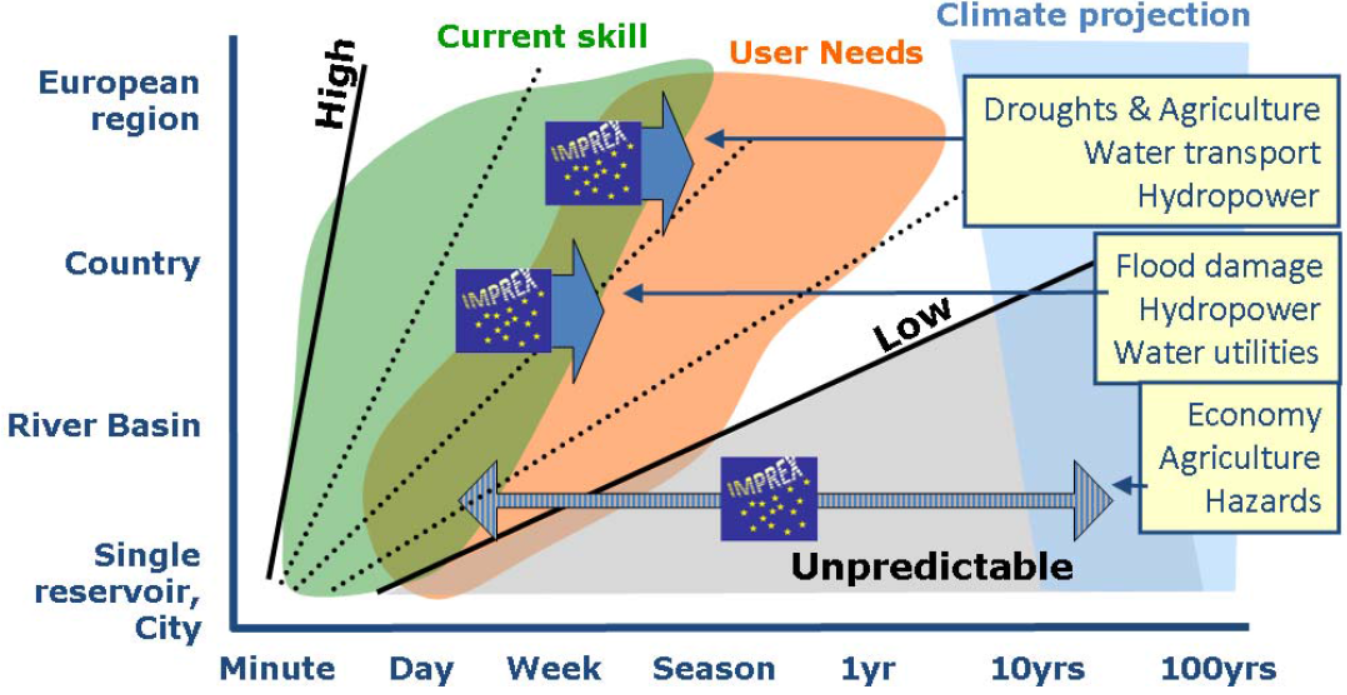
IMPREX mejorará la capacidad predictiva de las resoluciones de detalle y estacionales (las dos flechas superiores) e incorporará nuevos conceptos que pemitan adoptar la experiencia adquirida en los casos de estudio hacia el futuro (flecha inferior).

IMPREX proveerá diferentes elementos:

  • Mejoras cuantitativas en la capacidad para predecir la ocurrencia de eventos hidrometeorológicos extremos y sus imapactos.
  • Un conjunto de casos prácticos que demuestren la utilidad de las mejoras de predicción para la gestión eficiente de los eventos extremos.
  • Una aproximación de evaluación de riesgos novedosa que supere las limitaciones y falencias de los actuales métodos.
  • Una evaluación pan-europea de las actuales estrategias de gestión del riesgo y adaptación al cambio climático.
  • Una revisión periódica de los riesgos hidrológicos sobre los diferentes sectores de desarrollo europeo vinculando los resultados al Sistema Europeo de Alerta por Inundaciones (EFAS) y el Observatorio Europeo de la Sequía (EDO).

En el marco de IMPREX, FutureWater lidera la coordinación del grupo sectorial de trabajo especializado en “Sequías y Agricultura”. El objetivo de este paquete de trabajo es la puesta a punto de una metodología de vanguardia para la evaluación de riesgos en el sector agrícola mediante el uso combinado de pronósticos de tiempo y variabilidad climática, índices de sequía, y modelización agrohidrológica. La metodología se validará a nivel local en cuatro cuencas mediterráneas y a nivel paneuropeo. Este grupo de trabajo prestará un especial énfasis especial en:

  • Encontrar las relaciones entre la variabilidad del clima y los índices de sequía, y la producción y las pérdidas agrícolas en cuatro cuencas mediterráneas representativas.
  • Aplicar técnicas de escalado para proporcionar pronósticos de índices de sequía agronómicos útiles a nivel de cuenca y compatibles con las especificidades de los casos de estudio y sus sistemas de gestión de sequía.
  • Diseñar las herramientas, y los canales de comunicación y difusión apropiados para la generación de alertas tempranas y su provisión a a los gestores del agua y las partes interesadas del sector agropecuario.
  • Cuantificar analíticamente y de manera estandarizada el impacto del cambio de la precipitación, la evapotranspiración y la dinámica atmosférica en el balance y los flujos de agua, los patrones de consumo de agua y la prestación de servicios a la agricultura en las principales cuencas de Europa.

Enlaces

Videos