Nigeria as a country faces extensive Water Security Challenges (WSCs), from water availability and provisioning to water quality issues. These will become exacerbated by multiple future pressures, including huge increases in population and a changing climate. Oshun and Ogun catchments are located in the South West of Nigeria, in the same area as Lagos. These catchments face multiple challenges including unregulated groundwater extraction and poor sanitation infrastructure which compromise societal access to water.

NbS have the potential to contibute to addressing WSCs by increasing the overall resilience of the hydrological system, helping to increase infiltration to groundwater and buffer water quality issues. Alongside this, NbS can provide a wealth of co-benefits including carbon sequestration and increased biodiversity, complementing more traditional so-called ‘grey’ infrastructure such as pipelines and treatment plants.

Through extensive stakeholder consultation paired with GIS analysis and hydrological modelling, this project will help outline NbS which are best placed to address key WSCs, alongside identifying beneficiaries in the catchments of interest and existing parnerships in the catchment which are capable of delivering projects on-the-ground.

This work lays the foundations for the creation of so-called Watershed Investment Programmes (WIPs) in Osun and Ogun catchments, alongside the identification of further catchments in Nigeria which are disposed towards similar initiatives. WIPs aim to sustain and enhance the provisioning of key water-related ecosystem services by funding the conservation and restoration of lands that protect water quantity and quality. This is achieved through connecting downstream water users (e.g. water utilities, local governments, businesses, and the public) to upstream land managers (e.g. farmers and rural landowners). They unite these parties and others around the goal of enhancing water quality and quantity for societal benefits.

This consultancy project is framed by the AQUIFER project, “Innovative instruments for the integrated management of groundwater in a context of increasing scarcity of water resources” (Interreg-SUDOE V programme) which aims to capitalize, test, disseminate and transfer innovative practices for the preservation, monitoring and integrated management of aquifers.

FutureWater expertise was required for providing a novel and open-source hydrological modelling framework able to quantify spatial patterns of daily root percolation as a direct surrogate of groundwater recharge in the Campo de Cartagena Quaternary Aquifer (CC-QA). This aquifer is located at SE Spain and is one of the most important vectors of water drainage to the Mar Menor lagoon.

This task is addressed through the improvement and local calibration of the SPHY code for the Campo de Cartagena and the simulation of the water balance in the soil root zone from the 1950s until the end 2020. The SPHY-Campo de Cartagena includes a new routine able to compute irrigation inputs at the pixel level based on satellite data. Timeseries of monthly root percolation are taken as good surrogates of potential groundwater recharge and used as the main forcing input to an hydrogeological model of the Quaternary aquifer. The calibration process is performed through a sensititivity-intercomparison analysis in which model-derived outputs (irrigation and streamflow) during the calibration period are cross-checked against actual observations.

Spatial patterns of root percolation and the relative contribution of irrigation return flows to the total groundwater recharge were quantified (e.g. Figure 1) under historical and current conditions. Simulation results would show the lack of a significant temporal trend in the long-term recharge rates in the aquifer, most likely due to the the strong interannual variability observed in rainfall patterns, but also by the trade-offs resulting from the combination of climate, land use and irrigation-crop management drivers.

Figure 1. Mean Annual values of the main water balance components in Campo de Cartagena (2000-2020). RPer_ratio refers to the fraction between Root Percolation (MA.RPer) and Precipitation (MA.Pre)

The alarming decline of springs has been attributed to the rapid expansion of road networks, alongside changes in land cover and climate. Road development in these areas exposes springs to disturbances or alters their natural outflow, while rock cutting disrupts the location of spring orifices. This problem has largely gone unnoticed, posing a significant threat to the local communities and their water resources.

The overarching goal of the project is to reimagine roads as instruments for landscape improvement rather than adversaries, harnessing road development to contribute positively to local water resources. By integrating techniques and tools (Digital twins and DSS toolkit), the project aims to ensure safe and reliable water supplies for people in mountain areas while safeguarding the quality of road infrastructure and maintaining connectivity. The Dhankuta municipality and the Department of Local Infrastructure (DoLI), which regulates infrastructure development activities in Nepal, will be the primary beneficiaries of this project.

The expected results of the RoSPro project include:

  1. Successful implementation of roadside spring protection through pilot interventions in Dhankuta municipality and promote “Nature-based solutions” and “Green Roads for Water (GR4W)” approaches.
  2. Evidence generation on the impact of the pilot intervention through cost-benefit analysis.
  3. Assessment of the potential impact of upscaling roadside spring protection through the development of a digital twin and decision support toolkit.
  4. Capacity building for Dhankuta municipality and DoLI regarding roadside spring protection approaches, technologies, impact, and upscaling.

RoSPro will lead to improved water security for consumptive and productive uses, directly benefiting up to 500 households in the region. Following the pilot phase, the project aims to expand its services to established clients and partner networks in Asia and Africa. The demand for similar services is high in many high mountain countries, and RoSPro aims to generate a framework to upscale this at national and regional scales.

Thus, the RoSPro is a vital initiative that seeks to address the critical issue of dwindling springs in the Himalayas. By transforming road development into a contributor to local water resources, RoSPro will improve water safety and security, benefiting both the communities and the environment in these challenging mountainous regions.

Tajikistan has initiated the Water Sector Reform Program, aiming to enhance water resource planning and allocation across different river basin zones. However, the development of a comprehensive integrated water resources management plan is hindered by a lack of data on snow and glacier melt. The impact of climate change on the cryosphere, including changes in glacier ice storage, snow dynamics, and evaporation rates, further compounds the issue by affecting high mountain water supply and altering runoff composition and overall water availability.

To address this challenge, the «Integrated Rural Development Project» (IRDP), implemented by GIZ as part of the bilateral development project «Towards Rural Inclusive Growth and Economic Resilience (TRIGGER),» focuses on enhancing the value of agricultural production in Tajikistan. As part of the project, the Water Output (Output 1.5) provides technical support to the Ministry of Energy and Water Resources (MEWR) in the Zarafshon River Basin and at the national level. This support includes technical advisory services, capacity building, training measures, and improving access to irrigation water for small-scale farmers. Local relevant stakeholders foreseen as project beneficiaries are MEWR, Zarafshon River Basin (Zarafshon RBO), Center of Glacier Research (CGR), the Institute of Water Problems (IWP) and the Agency for Hydrometeorology, Tajikistan.

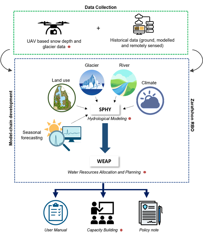
The project has three core components: data collection, modeling, and capacity building, as outlined below. Data collection will include both field monitoring campaigns using UAVs and retrieving historical records which could either be past in-situ observations, remotely sensed or modelled data. This comprehensive dataset will be used to set up, calibrate and validate Spatial Processes in Hydrology (SPHY) and WEAP models. The project will use the model-chain to provide the probabilistic flow forecast (likelihood to be in dry, medium, or wet conditions) using the seasonal meteorological forecast data. The SPHY-WEAP model-chain will then be deployed in the Zarafshon RBO-based servers. The results of the model-chain will be used to develop a comprehensive policy guidance note, proposing strategies and a way forward for developing a robust climate-resilient integrated water resources management plan that will ensure both water availability and accessibility across the river basin. Capacity building is a critical component of the project to ensure its sustainability and upscaling. Therefore, six capacity-building trainings (online and in-country) targeting different technical areas of the project will be organized throughout the project.

By undertaking these efforts, we aim to contribute to the successful implementation of Integrated Water Resources Management in Zarafshon and Tajikistan.

Over the last decades, efficient water resources management has been an important element of EU’s water policies, a topic that is addressed with renewed attention in the revised 2021 EU Adaptation Strategy, which lists the need for a knowledge-based approach towards water-saving technologies and instruments such as efficient water resources allocation. The IPCC special report on oceans and the cryosphere in a changing climate (2019) highlights the combination of water governance and climate risks as potential reasons for tension over scarce water resources within and across borders, notably competing demands between hydropower and irrigation, in transboundary glacier- and snow-fed river basins in Central Asia.

WE-ACT’s innovative approach consists of two complementary innovation actions: the first is the development of a data chain for a reliable water information system, which in turn enables the second, namely design and roll-out of a decision support system for water allocation. The data chain for the reliable water information system consists of real-time in-situ hydrometeorological and glaciological monitoring technology, modelling of the water system (including water supply and demand modelling and water footprint assessments) and glacier mass balance, data warehouse technology and machine learning. The roll-out of the DSS for climate-risk informed water allocation consists of stakeholder and institutional analyses, water valuation methods, the setup of the water information system to allow for a user-friendly interface, development of water allocation use cases, and feedback on water use through national policy dialogues.

The work of FutureWater within the WE-ACT study will focus on estimating the water demand and water footprints of the different users and activities within the Syr Darya river basin. Therefore, the effects of water allocation on water footprints, unmet water demand and environmental flow violations will be evaluated using a set of hydrological models such as SPHY and Water Allocation models (WEAP). This will be done for both the status quo and future scenarios.

For more information you can visit the WE-ACT project website.

Eswatini’s development is at risk by natural drought hazards. Persistent drought is exacerbating the country’s existing challenges of food security and the ability to attain sustainable development. Therefore, FutureWater, Hydrologic, and Emanti Management joined forces to bring together technologies and complementary expertise to implement the GLOW service which includes: short-term and seasonal forecasts of water availability and demand, an alerting service when forecasted water demand is higher than water availability, and water distribution advisories to reduce impact and maximise water security for all water users.

The GLOW service will be piloted in the Maputo River and Mbuluzi River Basins where three-quarters of the population of Eswatini lives, which includes the Hawane dam that supplies water to Mbabane (Capital City of Eswatini) and which is the major water supply source for Maputo, a Delta city (1 million inhabitants) which suffers from water shortages. The main beneficiaries of this project are the Joint River Basin Authority (JBRAS-PB) and the 5 River Basin authorities, AraSul (Mozambique) and the Department of Water and Sanitation (South Africa).

The innovation of GLOW is bringing together proven and award-winning technologies of advanced earth observation, open data, high-performance computing, data-driven modelling, data science, machine learning, operations research, and stakeholder interaction. These technologies require minimum ground truth information, which makes them very scalable and applicable in poorly monitored environments throughout the world. The coherent combination of the technologies into one decision support service ensures the optimum division of water, basically distributing every drop of water to meet the demands of all interests present in large river catchments.

Currently, farmers rely on weather forecasts and advisories that are either general for a given, often wide, region of interest, or highly customized to the farmers’ needs (e.g. by combining large scale atmospheric variables into synthetic parameters of interest). In both cases, such forecasts and advisories often don’t rely at all on observations collected at or around the target cultivated areas, or they are limited to traditional observations provided only by weather stations, without exploiting the full extent of measurements and observations available through European space-based assets (e.g. Galileo GNSS, Copernicus Sentinels) and ground-based radar data.

MAGDA objectives go beyond the state-of-the-art by aiming at developing a modular system that can be deployed by owners of large farms directly at their premises, continuously feeding observations to dedicated and tailored weather forecast and hydrological models, with results displayed by a dashboard and/or within a Farm Management System.

FutureWater is leading the irrigation advisory service of MAGDA, making use of hydrological modelling using SPHY (Spatial Processes in Hydrology). The output expected consists of an operational irrigation service to provide advice on when and how much to irrigate at certain moments during the cropping season, using as input data improved weather forecasts.

During this task, the SPHY water balance model will be setup for three selected demonstrator farms in Romania, France and Italy. Finally, the irrigation advisory will be validated using performance indicators (e.g., water productivity, crop yield analysis, water use efficiency) using ground truth data (e.g., weather stations, moisture probes, crop biomass measurements)

Uzbekistan is highly sensitive to climate change which will cause changes in the water flows and distribution: water availability, use, reuse and return flows will be altered in many ways due to upstream changes in the high mountain regions, but also changes in water demand and use across the river basin. The resulting changes in intra-annual and seasonal variability will affect water security of Uzbekistan. Besides, climate change will increase extreme events which pose a risk to existing water resources infrastructure. An integrated climate adaptation approach is required to make the water resources system and the water users, including the environment, climate resilient.

This project will support the Ministry of Water Resources (MWR) of Uzbekistan in identifying key priorities for climate adaptation in the Amu Darya river basin and support the identification of investment areas within Amu Darya river basin. The work will be based on a basin-wide climate change risk assessment as well as on the government priorities with an explicit focus on reducing systemic vulnerability to climate change.

The project will undertake:

  • Climate change risk analysis and mapping on key water-related sectors, impacts on rural livelihoods, and critical water infrastructures.
  • Climate change adaptation strategic planning and identify barriers in scaling up adaptation measures at multiple scales with stakeholder consultation and capacity building approach.
  • Identification of priority measures and portfolios for integration into subproject development as well as for future adaptation investment in the Amu Darya river basin. The identification will cover shortlisting of potential investments, screening of economic feasibility, and potential funding opportunities.

FutureWater leads this assignment and develops the climate risk hotspot analysis, and coordinates the contribution of international and national experts, as well as the stakeholder consultation process.

The Lunyangwa Dam is the source of water supply for Mzuzu City, Ekwendi Town and surrounding areas. Currently, the yield of the dam is lower than the annual average daily water demand from the dam. A quick intervention for this problem is to raise the spillway of the Lunyangwe Dam.

In order to determine the height of the redesigned spillway, FutureWater conducted a hydrological study for the Lunyangwa Dam Catchment to determine flood extremes for several return periods. HEC-HMS was used for calculating the peak volumes and discharges. The input for the HEC-HMS model was retrieved using satellite-based datasets for rainfall and terrain. Furthermore, the flood routing was simulated with an elevation-storage curve. The output of this study will be used for the redesign of the spillway.

The Asian Development Bank (ADB) identified the need for a detailed Climate Risk and Adaptation (CRA) assessment for the DKSHEP to understand the risk posed by the changing climate on hydropower and the environment. Therefore, the objective of this Climate Risk and Adaptation Assessment (CRA) is to assess the vulnerability of the project components to future climate change and recommend adaptation options for climate-proofing of the design. Therefore, this CRA covers both type 2 adaptation, related to system change and resilience building, as well as type 1 adaptation related to climate-proofing This CRA assesses historic trends in relevant climate-related variables and analyses climate projections for the DKSHEP. Based on these projections, an assessment of the current and future climate risks and vulnerabilities relating to the proposed project activities will be outlined. Finally, recommendations will be presented for climate adaptation measures.