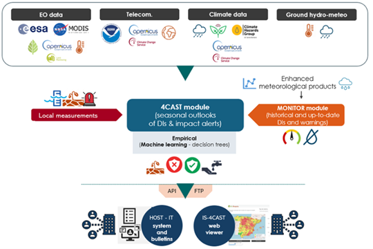
Currently, Pakistan’s energy mix consists of 58.8% thermal, 25.8% hydel, 8.6% nuclear, and 6.8% alternative sources, reflecting efforts to diversify from fossil fuels. Pakistan’s installed electricity generation capacity reached 41,557 MW by 2022, with significant growth in transmission line length over the past 5 years. However, the T&D system has not kept pace with the nearly 15,000 MW capacity added during 2017-2021 (ADB, 2024). Despite investments, transmission and distribution losses averaged about 18% over the last 5 years, exceeding the National Electric Power Regulatory Authority’s (NEPRA) 15.3% target. In 2020, 23.7% of generated energy was lost during transmission, distribution, and delivery (ADB, 2024). Notably, transmission and distribution losses exceed 25%, far higher than in comparable countries (GoP, 2017). Therefore, there is an urgent need to upgrade the existing distribution infrastructure to fulfill the energy demands and ensure steady socioeconomic development in the country. ADB will provide financing for four underperforming DISCOs, selected in consultation with the Ministry of Energy: Sukkur Electric Power Company (SEPCO), Hyderabad Electric Supply Company (HESCO), the Multan Electric Power Company (MEPCO), and the Lahore Electric Supply Company (LESCO) to:

  1. to upgrade the critical infrastructure of these DISCOs to reduce technical losses.
  2. to implement revenue protection measures to improve collections. Additionally, the project design includes embedded climate resilience and reform measures to enhance institutional capacity and financial sustainability.

These rehabilitation efforts will also take into account and address the growing impacts of climate change in four DISCOs. FutureWater will make use of state-of-the-art downscaled Coupled Model Intercomparison Project Phase 6 (CMIP6) ensembles, and other relevant hazards and local information to develop this CRA. Insights from the CRA will be used to devise adaptation strategies. Additionally, FutureWater will be reviewing the existing meteorological monitoring network and recommending additional potential monitoring sites for improved surveillance in the country. To further assist the Government of Pakistan, in actualizing its second Nationally Determined Contribution (NDC) agenda which seeks to reduce greenhouse gas (GHG) emissions per unit of GDP by 50% (compared to the level in 2016), by the year 2030, FutureWater will also develop a GHG account and prepare a Paris Agreement alignment assessment.

Increasing water scarcity continues to threaten the agricultural sector in Asia. To address this critical issue, FAO and its partners have been developing a comprehensive Asia-Pacific Water Scarcity Programme (WSP) since 2019. The program aims to assess the ongoing issue of water scarcity in the region, evaluate potential management options, and assist partner countries in implementing adaptive management in the agricultural water sector using innovative tools and approaches.

Addressing the issue of water scarcity requires a sound understanding and development of water accounts to ensure evidence-based decision-making for equitable use and allocation of water resources under a changing climate. To achieve this, a comprehensive hands-on training program on water accounting will be developed and implemented across four countries: Indonesia, Lao PDR, Vietnam, and Thailand. In collaboration with the Regional Office for Asia and the Pacific (RAP) of the Food and Agriculture Organization of the United Nations (FAO), FutureWater will design and deliver the water accounting training program. This program aims to not only improve participants’ understanding of water accounting but also enable them to use modern and innovative tools to develop water accounts, with a particular focus on quantifying linkages between field interventions and basin-scale hydrology.

Participants will work with tools such as REWAS and Follow the Water (developed by FutureWater in collaboration with FAO) to conduct water accounting in agricultural systems at different scales. Through the use of these tools, participants will be able to estimate real water savings at system and basin scales and analyze the impact of different irrigation schemes on the overall water availability in the system. Moreover, participants will also learn how to access and extract remotely sensed datasets to assess the status of the water resources in the Nam Ngum pilot basin.

La mayoría de las investigaciones recientes se han centrado en la identificación de episodios históricos basados en paleoregistros y la comprensión de sus causas climáticas, o en el estudio de megasequías “modernas” y sus impactos, generalmente en cuencas bajas y llanuras. Sin embargo, las cuencas de montaña han sido poco estudiadas y poco se sabe sobre el impacto de las megasequías en el estado y dinámica de la criosfera o torres de agua de montaña. Las cuencas vertientes dependientes de sistemas de alta montaña disponen de una capacidad para amortiguar la falta de precipitaciones y exceso de evapotranspiración que depende de las reservas de agua proporcionadas por la criosfera (nieve, glaciares y permafrost). Se presume, que la capacidad de amortiguación es limitada hasta alcanzar un punto de inflexión donde los impactos de la falta de agua y temperaturas extremas pueden verse amplificados y poner en peligro el funcionamiento del ecosistema hídrico.

MegaWat tiene un doble objetivo: 1) abordar las lagunas de conocimiento entorno a las causas hidroclimáticas de las sequías extremas y su impacto en el balance del agua de las torres de agua de montaña de Europa, haciendo especial énfasis en la concurrencia de eventos compuestos y los efectos en cascada y multiescala, y 2) desarrollar y proponer nuevas estrategias de adaptación para hacer frente a la duración, extensión e intensidad de futuras megasequías y sus impactos ambientales y socioeconómicos.

Para su implementación, MegaWat se centra en los sistemas de alta montaña de Europa y sus cuencas vertientes. MegaWat ambiciona el desarrollo de tres productos:

  • Producto 1. Marco metodológico para la identificación y caracterización de megasequías históricas durante el periodo instrumental, y la evaluación del papel que juega la criosfera en la amortiguación de los impactos del cambio climático y el desarrollo territorial en las cuencas vertientes. El producto 1 descansa en la combinación de herramientas de regionalización climática, modelización del balance de energía en superficie, simulación hidrológica, y códigos de evaluación y asignación optimización de recursos hídricos.
  • Producto 2. Base de datos climática regionalizada de alta resolución y de acceso libre.
  • Producto 3. Listado de estrategias de adaptación para la prevención y amortiguación de impactos, y el aumento de la seguridad hídrica y resiliencia de cuencas de alta montaña. Estos escenarios serán consensuados con agentes locales y partes interesadas, y su efectividad se evaluarán bajo escenarios extremos, no antes descritos pero plausibles, en tres cuencas piloto de alta montaña previamente seleccionadas por su representatividad, importancia estratégica y vulnerabilidad a las sequías.

En MegaWater, FutureWater coordina el paquete de trabajo para el desarrollo e implementación de herramientas de soporte a la decisión y adaptación a megasequías, incluyendo la organización de actividades con actores locales y partes interesadas para la priorización de intervenciones y puesta en común de resultados. El paquete de trabajo se organiza a través de dos actividades específicas: a) el desarrollo de un prototipo metodológico para cuantificación de impactos en cuencas vertientes y la identificación de puntos de inflexión para la seguridad hídrica, y b) el uso e integración de indicadores de estado de la criosfera en un sistema de alerta temprana, InfoSequia. como potenciales predictores de impacto y riesgo hídrico.

Representación esquemática de una cuenca de alta montaña, incluyendo los principales componentes, procesos e impactos relacionados con sequías.
Esquema del Sistema de Alerta Temprana InfoSequia desarrollado por FutureWater y adaptado para la detección de riesgos hídricos en cuencas de alta montaña. Más información sobre InfoSequia.

La ficha descriptiva de MegaWat se puede descargar aquí.

Agradecimientos

Este proyecto ha recibido financiación del programa Water4All con cofinanciación de CDTI y del Programa Marco de Investigación e Innovación «Horizonte Europa» de la Unión Europea”

Urban flood management in Laos is typically based on a limited, hard infrastructure approach. With the aim to shift this paradigm towards an integrated approach that enhances climate resilience, the project “Building resilience of urban populations with ecosystem-based solutions in Lao PDR” was approved by the Green Climate Fund Board in November 2019 with a GCF grant of US$10 million. United Nations Environment Programme (UNEP) serves as the Accredited Entity for the project. Activities are executed by the State of Lao PDR through the Ministry of Finance and Ministry of Natural Resources and Environment (MONRE) as well as UNEP. The project is implemented across five years (2020-2025) covering four provincial capitals in the country: Vientiane, Paksan, Savannakhet, and Pakse.

One component of the project involves technical and institutional capacity building to plan, design, implement and maintain integrated urban Ecosystems-based Adaptation (EbA) interventions for the reduction of climate change induced flooding. As a part of Integrated Climate-resilient Flood Management Strategy (ICFMS) development, the project conducts hydrological, hydraulic and climate risk assessments to inform climate change adaptation solutions for risk reduction in Vientiane, Paksan, Savannakhet and Pakse.

A consortium of FutureWater, Mekong Modelling Associates (MMA) and Lao Consulting Group (LCG) was contracted by MONRE to implement the related activities. FutureWater leads and coordinates this assignment and contributes remote sensing analyses with state-of-the-art innovative tools, climate risk assessments, and training activities. To ensure sustainability and effective technology transfer, the modelling and mapping infrastructure and trained staff will be hosted within MONRE and a knowledge hub that is established within the National University of Laos.


Southern Spain is a highly productive agricultural region, but with huge challenges around water scarcity and environmental sustainability. There is a demand in the agricultural sector to work towards water stewardship in Spain. The Alliance for Water Stewardship has developed a Standard which helps retailers and their suppliers to cause change at scale. This approach recognizes that there are common challenges that could be more easily overcome through a collective, place-based approach.

In the Doñana region, berry farms and groundwater usage are causing a conflict with the unique ecosystems in the National Park. A catchment assessment and active stakeholder engagement is needed as a first step in this region to work towards water stewardship. The catchment assessment will provide information on the catchment context, in line with the requirements of the Standard. The purpose of the assessment is to reduce the burden on agricultural sites by providing them with a common set of information which they and others can use to inform responses to their shared water challenges.

FutureWater will develop a high-level climate change and adaptation assessment for Turkmenistan to strengthen the water and agriculture sector’s resilience against climate change. The work involves a detailed hazard mapping exercise, employing observational and satellite-based information, to identify climate-related risks such as droughts, water scarcity, heat, salinity, erosion, and floods. These mapped hazards will be synthesized at the administrative level, presenting a comprehensive visual representation through figures and tables.

Key exposure and vulnerability datasets will be mapped, and pertinent sources for subsequent collection and analysis will be identified, setting the stage for a detailed risk assessment beyond the scope of work. The key output of this effort is the assembly of an inventory of climate adaptation measures gleaned from existing reports and official documents, contextualized to Turkmenistan’s unique circumstances, and an initial gap and opportunity assessment based on this inventory.

Based on the assessment, the adaptation options will be categorized and an initial prioritization will take place based on each option’s potential to mitigate risks across various hazards, its capacity for impactful outcomes beyond local scales, and a relative indication of expected cost-effectiveness. The outcome should provide a foundation for an integrated climate adaptation project. Concurrently, FutureWater will engage in country consultations, collaborating with stakeholders to confirm or refine identified adaptation options. These consultations will also explore potential synergies with ongoing and planned projects initiated by both the government and development partners.

To achieve the objectives the project has a technical component and stakeholder engagement component. On the technical side, hydrological models will be updated and validated. Climate change scenarios will be used as inputs for the testing of adaptation strategies within the Limpopo Basin. The adaptation include traditional grey infrastructure and additionally nature based solutions. The benefits analysis of the adaptation measure will cover macro and micro socio-economical benefits.

The results of this study will then be used to inform the development of a first-generation Transboundary Diagnostic Analysis (TDA) for the Limpopo River Basin (LRB). Through this, the individual basin countries will agree on a set of transboundary development priorities for the basin, which will guide both transboundary and national investments in the future, through a Strategic Action Plan (SAP) and National Action Plans (NAPs).

Within the project we cooperate with the hydrologists of ARA-Norte to discuss and establish the baseline for a water system analysis in the Monapo Catchment. Following discussion and mapping sessions, FutureWater is developing a Water Allocation Model in WEAP that includes climate change scenarios and mitigation and adaptation measures to asses the water availability of the catchment. Part of the assignment includes continuous training to local professional, to ensure the application of the developed model in the analysis of the system and elaborating specific proposal for implementation in the region.

The objective is to support the delineation and launching of a a Watershed Investment Program to improve multi-stakeholder collaboration and sustainable funding mechanisms to protect and restore riparian buffer zones and to implement runoff attenuation features to reduce eroded sediments entering the river.

To support the science streams, FutureWater is applying open source tools such as INVEST and RIOS Tool, together with Remote Sensing analysis to elaborate on a NbS opportunity mapping analysis. Besides, we aim to provide quantitative results on NbS benefits to reduce sediment loads entering the river system.

Nigeria as a country faces extensive Water Security Challenges (WSCs), from water availability and provisioning to water quality issues. These will become exacerbated by multiple future pressures, including huge increases in population and a changing climate. Oshun and Ogun catchments are located in the South West of Nigeria, in the same area as Lagos. These catchments face multiple challenges including unregulated groundwater extraction and poor sanitation infrastructure which compromise societal access to water.

NbS have the potential to contibute to addressing WSCs by increasing the overall resilience of the hydrological system, helping to increase infiltration to groundwater and buffer water quality issues. Alongside this, NbS can provide a wealth of co-benefits including carbon sequestration and increased biodiversity, complementing more traditional so-called ‘grey’ infrastructure such as pipelines and treatment plants.

Through extensive stakeholder consultation paired with GIS analysis and hydrological modelling, this project will help outline NbS which are best placed to address key WSCs, alongside identifying beneficiaries in the catchments of interest and existing parnerships in the catchment which are capable of delivering projects on-the-ground.

This work lays the foundations for the creation of so-called Watershed Investment Programmes (WIPs) in Osun and Ogun catchments, alongside the identification of further catchments in Nigeria which are disposed towards similar initiatives. WIPs aim to sustain and enhance the provisioning of key water-related ecosystem services by funding the conservation and restoration of lands that protect water quantity and quality. This is achieved through connecting downstream water users (e.g. water utilities, local governments, businesses, and the public) to upstream land managers (e.g. farmers and rural landowners). They unite these parties and others around the goal of enhancing water quality and quantity for societal benefits.