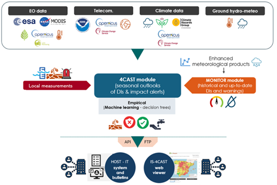
Recientemente se ha publicado un artículo científico en Remote Sensing (doi: 10.3390/rs17111855) en el que se presenta la avanzada tecnología desarrollada por el proyecto MAGDA, que integra múltiples plataformas de sensores y herramientas de modelización para mejorar las previsiones meteorológicas agrícolas y los avisos de riego.
Esta nueva investigación ofrece un gran avance en la agricultura de precisión al combinar datos de satélites europeos, drones, sensores terrestres y señales GNSS para una vigilancia meteorológica y de la humedad del suelo muy localizada y precisa.
El sistema MAGDA ofrece ventajas significativas al mejorar las predicciones meteorológicas a corto plazo y la programación del riego a escala de campo, abordando así los retos que plantean el cambio climático y las condiciones meteorológicas extremas. Los agricultores tienen acceso a información precisa que ayuda a optimizar el uso del agua, reducir el despilfarro y proteger mejor los cultivos de sequías, inundaciones y granizadas.
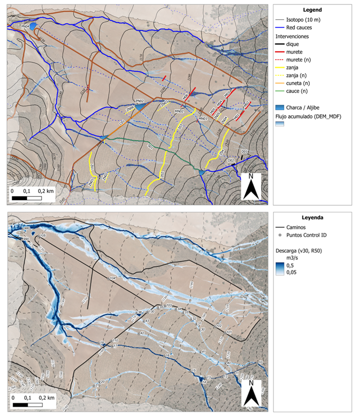
Un componente clave del sistema MAGDA es IrriSPHY-1D, un avanzado modelo agrohidrológico potenciado por FutureWater integrado en el servicio de asesoramiento sobre riego de MAGDA. IrriSPHY-1D simula con precisión la dinámica de la humedad del suelo en la zona radicular de los cultivos y calcula las necesidades de agua para riego (IWR) con más exactitud que nunca. Esta capacidad mejorada permite a los agricultores optimizar las tasas de aplicación de agua, reducir los residuos y minimizar el impacto medioambiental de las prácticas de riego.
La integración en IrriSPHY-1D de conjuntos de datos MAGDA -incluidos datos atmosféricos de alta resolución procedentes de Meteodrones, humedad del suelo obtenida por satélite y humedad del suelo recuperada mediante reflectometría GNSS- mejora significativamente los avisos de riego. Esta fusión de datos permite al sistema proporcionar previsiones de riego más fiables y procesables, mejorando la gestión del agua y la resistencia de la agricultura.
Con este enfoque innovador y la marca de validación científica, FutureWater y los socios de MAGDA han hecho una contribución significativa al avance de las prácticas agrícolas sostenibles y resistentes al clima en toda Europa.