Autor: Amelia Fernandez
17 noviembre 2022
FutureWater Academy Training Platform Launched
In response to the pressing global challenges related to water, agriculture and ecosystem services, the availability of data and tools to support decision makers in these fields has grown rapidly in recent years. Public agencies, NGOs and researchers therefore need to continuously develop their capacity to make optimal use of these resources. To support our...
3 noviembre 2022
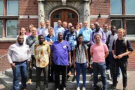
FutureWater Presented Two New Services at the TWIGA Final Conference
The TWIGA Final Conference was held on 11 and 12 July as a hybrid event in De Oude Bibliotheek in Delft, the Netherlands, and online. The event gathered on both days 27 participants present in person and 15 online, including consortium partners, representatives of two sister projects AfriCultuReS and e-Shape, Advisory Board members, and the...

4 octubre 2022
Towards a Safe Operating Space for Water Resources in a Changing Climate and Society
Starting on the 1st of October, 2022, the SOS-Water Project, funded under the Horizon Europe scheme, will create a holistic and participatory assessment framework of a Safe Operating Space (SOS) for the entire water resources system to inform global and regional water management policies and pathways. Water resources around the globe are under increasing stress....
3 octubre 2022
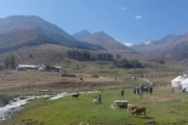
Opportunities for Regional Cooperation and Water Resilience in Central Asia Identified
Early September, FutureWater supported the Asian Development Bank in an extensive consultation of key stakeholders of the five countries in Central Asia, on possible activities to be integrated in the CAREC Water Pillar: an investment vehicle for regional cooperation and climate resilience for the region. Many physical meetings took place with the key ministries involved...
30 septiembre 2022
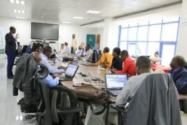
Strategic Water Resources Options Prioritized for Rwanda
FutureWater and the Rwandan firm and consortium partner ENTREM presented interim results of the Integrated Strategic Water Resources Planning and Management project. The key objective of this study is to support the country on its path towards sustainable development towards 2050 by identifying strategies to better regulate and manage the available water resources through natural...
26 septiembre 2022
Training on Real Water Savings in Eight Countries Completed
Achieving water savings in agricultural systems is challenging and many projects in the past have failed to deliver the expected water savings. To achieve real water savings, FutureWater and FAO have organized training courses on Real Water Savings in Agricultural Systems (REWAS) in eight Asian countries. The Food and Agriculture Organization Regional Office of South...
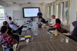
22 septiembre 2022
Methodology Developed for Climate Change and Water Security Risk Tool
FutureWater is supporting the Asian Development Bank in developing the methodology for a new state-of-art Climate and Disaster Risk screening tool. The methodology behind the tool and the reports to be produced by the tool are currently undergoing an internal multi-sectoral consultation process. The goal is that the targeted users of the tool provide feedback...
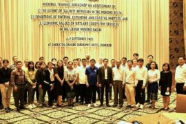
19 septiembre 2022
Training on Assessing Lower Mekong Salinity Intrusion and Habitat Conditions Successfully Organized in Bangkok
Over the past year, FutureWater has supported Mekong River Commission (MRC) by developing and implementing a set of satellite remote sensing-based methodologies for evaluating the extent of Salinity Intrusion in the Mekong Delta (SIM), as well as the conditions of Riverine, Estuarine and Coastal Habitats (RECH) in the Lower Mekong Basin. The developed methods rely...
16 septiembre 2022
FutureWater Provided Training Course on Climate Smart Agriculture to Egyptian Agribusiness Professionals
Last week, Martijn de Klerk, Corjan Nolet, and Tijmen Schults provided an in-person training on Climate Smart Agriculture and geodata and modeling tools for participants representing SMEs from the Egyptian agricultural sector. The training was part of the SASPEN (Sustainable Agriculture Service provision Enterprise Network in Egypt) project, implemented by Care Egypt. The training took...
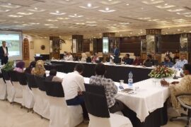
5 agosto 2022
FutureWater visits Pakistan for Water Accounting Methodology Sharing Workshops and Stakeholder Consultations
On 25th July and 2nd August 2022, FAO Pakistan conducted a Water Accounting Methodology Sharing workshop in Lahore (Punjab) and Karachi (Sindh), respectively. Peter Droogers (Senior Hydrologist) and Tania Imran (Consultant) from FutureWater joined the workshop to deliver introductory sessions on the concept of water accounting and the potential use of remote sensing. The workshop...
