
The main objective of this study is to explore the potential to combine optical and gravity data from Earth Observation with meteorological data, together with innovative in situ sensors, hydrological modelling and crowd sourcing technologies, and the advanced visualization of the information through situation awareness platforms and decision support tools, in order to better monitor, forecast and control the quality and availability of water in the United Kingdom. In this project FutureWater will use Flying Sensors to acquire information on land use, elevation, river water quality, leakage detection and flood monitoring. Furthermore hydrological modelling will be carried out to generate water availability forecasts.
Water supply and sanitation in the United Kingdom is modern and of good quality. However, increasing pressure on freshwater resources is a major concern to UK. Water is needed for irrigation, forestry, industrial users, environmental flows for country’s river systems, and for human consumption. With increasing pollution and economic growth, these pressures will continue to increase over the coming decades, making it more important to have accurate information about the sources and availability of water, as well as the consumption of water such as monitoring the amount that is pumped from the groundwater sources.
The assessment of water quality (nitrates, pesticides, bacteria, salt, and algae) in the distribution networks is highly relevant for public health and the estimation of industrial and natural sources and impacts is a priority. The improvement of the water availability estimation (stored in soil and reservoirs) is crucial, in order to improve the planning of distribution and the forecast of possible floods and droughts. Also, the infrastructures such as pipes of drinking water and sewage are critical elements, and the improvement of monitoring could allow faster response time and leading to easier maintenance in case of disruptions. Water managers and planners have been using data from satellite sensors to support catchment level monitoring and forecasting, to estimate parameters such as assess the impact of land use change on water availability. Earth Observation data (EO) is increasingly being used for compliance monitoring.
EO is an important enabling technology for the better management and accounting of UK’s water resources. The main objective of this study is to explore the potential to combine optical and gravity data from EOS with meteorological data, together with innovative in situ sensors, hydrological modelling and crowd sourcing technologies, and the advanced visualization of the information through situation awareness platforms and decision support tools, in order to better monitor, forecast and control the quality and availability of water. Not only the resulting services will be useful for the water industry in UK, but also they are expected to be cost-effective, sustainable, and exportable to broader user groups such as farming industry, environment board, as well as other countries where water issues can be tackled with the same tools.
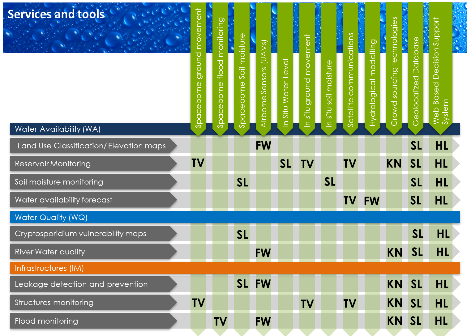
FutureWater is mainly involved in the following tools and services to be explored during this project:
Airborne Sensors (UAVs):
- Land use classification/elevation maps
- River water quality
- Leakage detection and prevention
- Flood monitoring
Hydrological modelling:
- Water availability forecast