FutureWater supports Fiera Comox in its due diligence process for the acquisition of a vertically integrated tree-fruit operation in North Spain. Particularly, FutureWater addresses an overall assessment of the most important water-related factors of risk that may control the current and medium-term feasibility of the fruit orchard farming system of interest. The application of FutureWater’s approach applies a multicriteria analysis and allows to qualify the levels of risk for each key factor analyzed.

FutureWater’s approach rests on: 1) the collection and analysis of data retrieved from documents, large datasets, and in-situ field inspections and stakeholder interviews, and 2) the scoring of the risks previously identified based on a final expert judgment.

Key sources of information for this risk screening included:

  • Existing documentation, reports, plans, and local legislation that may affect the access to water for irrigation
  • Existing and publicly accessible spatial and GIS data, including satellite imagery and thematic datasets available through national and regional agencies and platforms (Ebro River Basin Authority, National Infrastructure of Geospatial Data, Spanish Information System of Water)
  • Meteorological data (rainfall and temperature) from nearby weather stations
  • Groundwater level from the Spanish National Ministry of Environment.
  • Private data and documents generated by clients and stakeholders through personal and follow-up communications with farmer

Key variables analyzed and evaluated at the district and regional scales, to the extent relevant to the farm, included:

  • Water availability of surface and groundwater resources. For groundwater, a trend analysis of water levels, and first-order assessment of quality constraints and risks is included.
  • Impacts of climate change on water resources availability based on rainfall and temperature trends and projections for the region.
  • Water quality for irrigation purposes.
  • Potential conflicts due to competition for water in agriculture and other sectors of activity.

Legislative and policy-related factors that may affect the overall performance were also analyzed risk-by-risk.

Four factors of risk were analyzed: water availability, climate change, water quality, and water conflict. Each factor of risk was scored according to a risk matrix in which levels of probability of occurrence and impact severity were qualified based on data and expert judgement. For each factor, a risk matrix with three levels of overall risk were adopted: Low Risk (L), Moderate Risk (M), and High Risk (H)
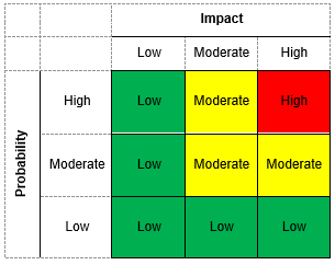
Figure 1. Overall risk levels when probability of occurrence and impact severity are qualified.
Figure 2. Overview of risk assessment by factor.

In this particular project, the approach was implemented in four different settings located in the area.
For smallholder farming systems, there is a huge potential to increase water productivity by improved (irrigated) water management, better access to inputs and agronomical knowledge and improved access to markets. An assessment of the opportunities to boost the water productivity of the various agricultural production systems in Mozambique is a fundamental precondition for informed planning and decision-making processes concerning these issues. Methodologies need to be employed that will result in an overall water productivity increase, by implementing tailored service delivery approaches, modulated into technological packages that can be easily adopted by Mozambican smallholder farmers. This will not only improve the agricultural (water) productivity and food security for the country on a macro level but will also empower and increase the livelihood of Mozambican smallholder farmers on a micro level through climate resilient production methods.

This pilot project aims at identifying, validating and implementing a full set of complementary Technological Packages (TP) in the Zambezi Valley, that can contribute to improve the overall performance of the smallholders’ farming business by increasing their productivity, that will be monitored at different scales (from field to basin). The TPs will cover a combination of improvement on water, irrigation, and agronomical management practices strengthened by improved input and market access. The goal is to design TPs that are tailored to the local context and bring the current family sector a step further in closing the currently existing yield gap. A road map will be developed to scale up the implementation of those TPs that are sustainable on the long run, and extract concrete guidance for monitoring effectiveness of interventions, supporting Dutch aid policy and national agricultural policy. The partnership consisting of Resilience BV, HUB, and FutureWater gives a broad spectrum of expertise and knowledge, giving the basis for an integrated approach in achieving improvements of water productivity.

The main role of FutureWater is monitoring water productivity in target areas using an innovative approach of Flying Sensors, a water productivity simulation model, and field observations. The flying sensors provide regular observations of the target areas, thereby giving insight in the crop conditions and stresses occurring. This information is used both for monitoring the water productivity of the selected fields and determining areas of high or low water productivity. Information on the spatial variation of water productivity can assist with the selection of technical packages to introduce and implement in the field. Flying sensors provide high resolution imagery, which is suitable for distinguishing the different fields and management practices existent in smallholder farming.

In May 2020, FutureWater launched an online portal where all flying sensor imagery from Mozambique, taken as part of the APSAN-Vale project, can be found: futurewater.eu/apsanvaleportal

Project video: Portrait of the activities on water productivity

The scope of the project work is as follows:

  • Train selected NCBA Clusa PROMAC staff on drone operation, imagery processing software, and crop monitoring;
  • Provide technical assistance to trained NCBA Clusa staff on drone operation, imagery processing, and interpretation of crop monitoring data;
  • Present technical reports on crop development and land productivity (i.e. crop yield) at the end of the rainy and dry season

The trainings and technical assistance for the NCBA Clusa staff are provided in collaboration with project partners HiView (The Netherlands) and ThirdEye Limitada (Central Mozambique). Technical staff of the NCBA Clusa are trained in using the Flying Sensors (drones) in making flights, processing and interpreting the vegetation status camera images. This camera makes use of the Near-Infrared wavelength to detect stressed conditions in the vegetation. Maps of the vegetation status are used in the field (with an app) to determine the causes of the stressed conditions: water shortage, nutrient shortage, pests or diseases, etc. This information provides the NCBA Clusa technical staff and extension workers with relevant spatial information to assist their work in providing tailored information to local farmers.

At the end of the growing season the flying sensor images are compiled to report on the crop development. The imagery in combination with a crop growth simulation model is used to calculate the crop yield and determine the magnitude of impact the conservation agriculture interventions have in contrast with traditional agricultural practices.

Significant decisions are to be made to manage and engineer the water systems in Myanmar and to develop large structural and non-structural projects (e.g. hydropower dams, urban water use, industrial development, extension of irrigation capacity, operational quantity and quality management, etc.). Global experience shows that such activities can have irreversible consequences and impose significant costs to economies, cultures and the environment. Early integration of inclusive management strategies can prevent future problems. This is recognized in Myanmar. The Myanmar and Dutch governments have agreed to cooperate on Integrated Water Resources Management (IWRM) through a Memorandum of Understanding (MoU) between the Myanmar Ministry of Transport and Dutch Ministry of Infrastructure and the Environment. To build on the activities that have been performed under this MoU, the project “Leapfrogging Delta Management in Myanmar” was initiated by TU Delft, FutureWater and HKV Consultants, and funded under the Partners for Water program.

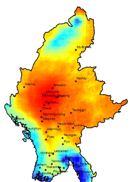
Precipitation in Myanmar

Most monitoring and all operations in Myanmar are currently not near-real time. In the Ayeyarwady Delta some real-time data collection stations for water level, rainfall and water salinity measurements have been installed. Yet most data, such as rainfall and water levels, are collected on paper and sent to central offices by post, which can take 2 months. There are also data gaps in the monitoring network, automatic collection of data can diminish the data gaps. Surface water quality is measured only twice a year. Stage-discharge curves once every five years, which is insufficient as the Myanmar rivers are changing rapidly, leading to inaccurate discharge data. Besides monitoring, the big challenge in Myanmar is to convert raw data into useful information for (end) users. Dutch companies have developed tools and assimilation schemes to combine data and convert it into useful and understandable information for different types of clients and users.

In response to the request of the NWRC in Myanmar and the interest of Dutch innovative enterprises, the project’s main aim is to extend the current work in the Bago-Sittaung to the whole Ayeyarwady Delta in accordance with the agreement between the Myanmar and Dutch governments. The aim is to test and demonstrate innovative smart information solutions in the Delta and disseminate the results widely. Coalitions are created around specific information products (e.g. rainfall, erosion, subsidence). In each coalition, partners work on innovative monitoring: to combine remote sensing, ground data collection with modelling techniques. Opportunities and limitations are discussed with Myanmar professionals. In phase two of the project these innovations are tested, both in the field as well in a data platform environment. Innovative technologies and methods will be adjusted according to local circumstances and requirements in consultation with Myanmar. The successful proven innovations are demonstrated during two demonstration weeks in phase three, in which the entrepreneurs explain the products and the results of the testing to the Myanmar stakeholder and (end) users and to the international donors active in this field in Myanmar.

The results of the project will be presented in an online platform based on HKV Dashboard technology, to disseminate the products and services to a local and international audience. Throughout the entire project Dutch and Myanmar experts and young professionals will work together (learning-by-doing) and dissemination and training will be organized. This will facilitate easy adaptation and implementation of the innovations within the Myanmar government.

Based on its experience in operational rainfall monitoring and downscaling to high resolutions using satellite-derived information, FutureWater is developing the first near-real-time spatial rainfall product for Myanmar. The global algorithms will be tailor-made to the Myanmar situation. The first results come available through the online platform over the course of 2017.

There are strong indications that the risk of infection in humans with Q fever depends on physical environmental factors such as warm weather with dry soils and a certain wind. Wind with enough speed and the right direction can bring out dust particles in the air that bacteria capture. These can then be inhaled by humans and animals in the surrounding area. It is believed that aerosols can move several kilometers by wind in dry, dusty conditions. Q fever outbreaks in humans took place in the Netherlands in 2007, 2008 and 2009, increasing in size.

The magnitude of the outbreaks in the Netherlands indicates that the transmission occurs through large scale pollution or by the existence of multiple contaminated point sources, and not so much by direct (professional) contact with animals or for example consumption of contaminated unpasteurized milk. So far, conclusive evidence is lacking to what factors influence the risk of infection the most. In some infected farms little or no infection is detected in humans while other sources have passed over to humans; regardless the size of the farm.

All this raises the question of whether physical environmental factors in certain areas of infection were more conducive for transmission than elsewhere. In this study, the influence of these factors, soil type and, in particular, usage and humidity are examined, taking into account the population density, company size, production methods and weather conditions.

Rainwater harvesting aims at reaching those people not having access to sufficient and good quality fresh water. They often live in rural areas where other means of water supply are not sufficient or feasible. Within these areas groundwater is not accessible (at technically and/or financially unreachable depths) or potable (due to water quality issues, like fluoride or arsenic contamination) and other surface water (like permanent rivers, lakes and springs) are not available or sufficient to meet basic water needs.

Identifying areas where rainwater harvesting is a feasible solution is one of the aims of the RAIN Foundation. This information on the potential of rainwater harvesting is essential to guide organizations in their implementation efforts, and is at the same time important as a strong lobby tool towards national and international governments.

Besides the current potential, a future oriented approach is required as changes in climate and socio-economic development would alter the need and the potentials for rainwater harvesting. In the years to come, temperatures will rise worldwide, but the weather will also become more extreme. Both prolonged droughts and floods, whether or not combined with sea level rise, are causing a shortage of clean drinking water.

In 2010 FutureWater and Deltares were asked by RAIN Foundation to develop maps indicating the potential for rainwater harvesting (RWH) for Mali, Senegal and Burkina Faso. FutureWater and Deltares used the same approach, but with a slightly different set of input parameters. This report describes the recommended approach to develop maps showing the potential for rainwater harvesting.

The interactive maps can be found here: Rainwater Harvesting Potential in Mali, Senegal & Burkina Faso

Las sequías son periodos transitorios en los que los valores de precipitación son inferiores a los considerados normales o promedios. El término sequía es un concepto relativo cuya definición depende del dominio geográfico y del ámbito de afección que se considere. Las sequías pueden ser meteorológicas cuando se asocia a escasez de precipitaciones, agronómicas cuando las condiciones de humedad en el suelo afectan la producción de los cultivos, hidrológicas en el caso de que se reduzca de forma efectiva la disponibilidad de agua en ríos, embalses o acuíferos, o socioeconómicas cuando los efectos de la escasez de agua impacta negativamente en los sectores productivos de una sociedad. Es altamente previsible que un incremento en la frecuencia, intensidad y severidad de las sequías también reduzca la capacidad de las sociedades para hacer frente a sus impactos poniendo en riesgo su seguridad hídrica y alimentaria.

Picture1

Garantizar la sostenibilidad ambiental y socioeconómica en las regiones semiáridas del planeta, en un contexto global caracterizado por una mayor recurrencia de sequías prolongadas1, dependerá de la existencia de herramientas versátiles que permitan anticipar y alertar sobre su llegada, y predecir, gestionar y mitigar sus consecuencias. En la actualidad, la consecución de este objetivo se ve ampliamente favorecido por una mayor disponibilidad de datos de satélite y de un crecimiento exponencial de la capacidad de cómputo que posibilita, a la misma vez, la generación de nuevos datos. Sin embargo las tasas de generación de nueva información resultan ser muy superiores a las habilidades para ser integradas e interpretadas de manera sintética, rápida y eficiente (paradoja de la información).

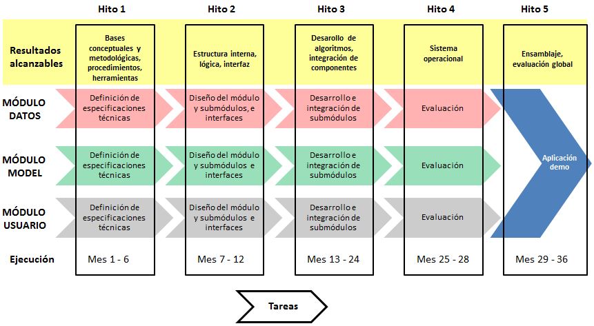
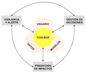
El proyecto GEISEQ desarrollará un prototipo un Sistema de Soporte a la Gestión Integral de Sequías sustentado en una herramienta para: a) la detección, vigilancia y seguimiento de sequías, b) la predicción y análisis espacial de impactos, y c) la toma de decisiones. GEISEQ favorecerá el procesamiento y la conectividad eficiente entre los datos disponibles, una librería de modelos de simulación, y las estrategias de decisión manejadas por el usuario/gestor, mediante el empleo de aplicaciones GIS, la adquisición información de satélite, y la implementación de técnicas estadísticas para la asimilación y minería de datos.

Flujo_trabajo

Indice de sequía agronómica en la Región de Murcia


Figura 3. Desviación acumulada del verdor de satélite en una muestra de cultivos de secano en la región de Murcia.

Informes y notas de prensa

– La Verdad de Murcia, 20 octubre 2015, reportaje en Suplemento «Nuestra Tierra». Murcia en el ojo de la sequía.
– Onda Regional Murcia, 24 junio 2014, entrevista de radio. Una ‘spin-off’ de la UPCT sabe cómo prevenir los efectos de la sequía.
– Nota de Prensa FutureWater, 22 mayo 2014. El verdor de secano advierte de la severidad de la sequía.

Agradecimientos

El proyecto GEISEQ está cofinanciado por el FONDO SOCIAL EUROPEO (FSE) a través de la concesión de un contrato asociado al Subprograma Torres Quevedo y gestionado por el Ministerio de Economía e Innovación (referencia: PTQ-12-05412)
logo_meinn_fse_geiseq

This project was a three-year scientific research project supported by the Casimir program of NWO, that aimed at promoting the exchange of researchers between the private and academic sector. The project focused on the hydrology and cryosphere of the Himalayas and dealt with the influence of snow cover of the Himalayas and the Tibetan plateau on Asian monsoon dynamics, and the possibility to forecast the strength of the monsoon and the hydrological effects in downstream areas. This was further detailed though four specific research questions:

  1. What are the spatial and temporal patterns in snow cover in the Himalaya and on the Tibetan plateau?
  2. Are there empirical relationships between snow cover, the El Nino – Southern Oscillation (ENSO), surface temperature and monsoon precipitation?
  3. What is the effect of snow cover on monsoon precipitation, and what are the major underlying processes?
  4. Is it possible to forecast the downstream hydrological effects during the monsoon based on pre-monsoon information of snow cover and ENSO status?

The project was executed in close collaboration with the department of Physical Geography of Utrecht University.

Links

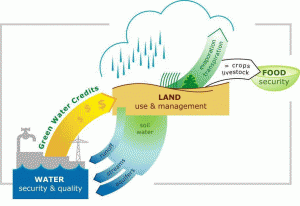
Green Water Credits can be seen as an investment mechanism for upstream farmers to practice soil and water management activities that generate benefits for downstream water users, which are currently unrecognized and unrewarded. This initiative is driven by economic, environmental and social benefits. The implementation of GWC has the potential of enhancing overall water management by reducing damaging runoff, increase groundwater recharge, simulate a more reliable flow regime, and reduce harmful sedimentation of reservoirs.

Green Water Credits: the concept.

FutureWater coordinated and carried out the biophysical assessment that quantifies the impact of Green Water Credits practices on the green and blue water and sediment fluxes in the Upper Tana basin. The analysis leads to identification of potential target areas for GWC pilot operation on biophysical grounds. This required a distributed modeling approach (SWAT) accounting for the heterogeneities in the basin in terms of precipitation regime, topography, soil characteristics and land use. The developed tool quantifies the benefits of the management practices on erosion reduction and green and blue water flows in the basin.

Links

Debido a los eventos hidrometeorológicos extremos acaecidos en 2011, el gobierno colombiano y las agencias regionales encargadas de la gestión del agua se vieron forzados a prestar una mayor atención a los aspectos relacionados con la seguridad del agua y de las presas, a la vez que se activaron programas de colaboración exterior y en especial con las autoridades holandesas.

El objetivo del proyecto fue mejorar las capacidades técnicas de las instituciones colombianas en materia de evaluación de recursos hídricos y gestión adaptativa al cambio climático. Se han ofrecido herramientas y capacitación para:

  • Cuantificar el impacto del cambio climático en el riesgo de inundaciones y la disponibilidad de agua.
  • Identificar umbrales críticos para la seguridad hídrica de los sistemas de agua y esbozar posibles rutas de adaptación.
  • Proporcionar herramientas/enfoques que apoyen los procesos de planificación de los recursos hídricos para hacer frente a las incertidumbres del cambio climático y otros desarrollos futuros en cuencas hidrográficas de pequeño y gran tamaño.
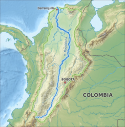
  • Demostrar la aplicabilidad y utilidad de las herramientas para dos casos piloto: una cuenca pequeña (Coello-Combeima) y una grande (Magdalena). En ambas se realizaron actividades de capacitación técnica.
  • Explorar oportunidades de mejora dentro de Colombia y otros países de América Latina.

Las actividades de este proyecto piloto incluyen el análisis del clima histórico a partir de observaciones y del clima futuro con modelos de circulación general (GCM) escalados regionalmente. Las extensiones históricas de las inundaciones y el uso de la tierra se analizan con imágenes radar de satélite. Se desarrolla un modelo hidrológico para evaluar los impactos climáticos en la disponibilidad de agua y la frecuencia y extensión de las inundaciones. Se desarrolla un modelo de asignación de agua basado en la herramienta de modelización WEAP para analizar cómo el suministro de agua actual y futuro se relaciona con las demandas sectoriales de agua. Se determinan los puntos de inflexión para la seguridad hídrica y se evalúan los efectos de las diferentes vías de adaptación utilizando los modelos. Los resultados se presentan y discuten en eventos organizados con las partes interesadas.

Los proyectos apoyan la elaboración de la Estrategia Nacional de Adaptación de Colombia a ser elaborada en 2013 y se espera que esté terminada en 2014. Así mismo, entre septiembre y noviembre de 2014 se desarrollará el Plan Nacional de Desarrollo en el que se definen los planes e inversiones para el horizonte 2014-2018. El Departamento Nacional de Planificación de Colombia espera que los objetivos y enfoques del presente proyecto sean empleados para enriquecer los instrumentos de planificación y la estrategia política nacional.

El consorcio trabaja con una lista de socios locales que incluye: el Instituto de Hidrología, Meteorología y Estudios Ambientales de Colombia (IDEAM ), Departamento Nacional de Planificación de Colombia (DNP), Corporación Autónoma Regional del Magdalena (CORMAGDALENA), y Corporación Autónoma Regional del Tolima (CORTOLIMA).

El proyecto está financiado por los socios del consorcio y una ayuda del gobierno holandés a través del Programa Partners Voor Water de la Agencia Empresarial de los Países Bajos.